Grodzisk geodata
Grodzisk (Podlasie) is a populated place; located in Poland in Europe/Warsaw (GMT+2) time zone. With population of 640 people, there are 3187 cities with bigger population in this country. Compared to other cities in Poland, 77.7% of cities are located further ↓South; 94.1% of cities are located further ←West and 54.9% of cities have higher elevation than Grodzisk. Note1


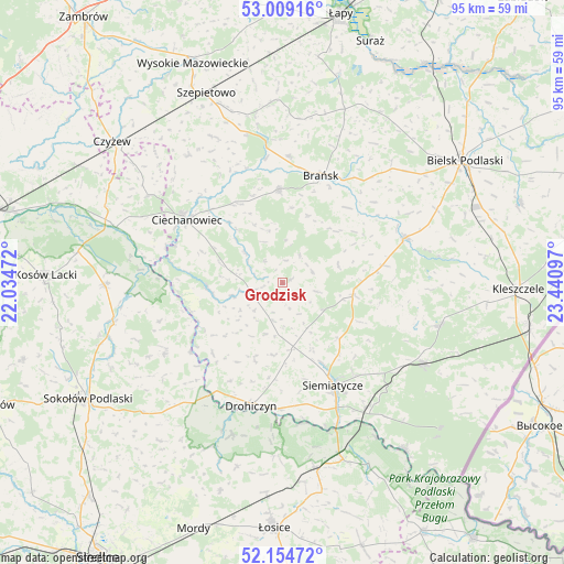
Grodzisk GPS coordinates[2]
52° 35' 2.472" North, 22° 44' 16.224" East
| Map corner | latitude | longitude |
|---|---|---|
| Upper-left | 53.00916°, | 22.03472° |
| Center: | 52.58402°, | 22.73784° |
| Lower-right: | 52.15472°, | 23.44097° |
| Map W x H: | 95×95 km | = 59×59mi |
| max Lat: | 54.83135° ⇑22.3% North |
| Grodzisk: | 52.58402° |
| min Lat: | ⇓77.7% South 49.21328° |
| min Long | Grodzisk | max Long |
| 14.20249° | 22.73784° | 24.03723° |
| W 94.1%⇐ | ⇒5.9% E |
Elevation
Elevation of Grodzisk is 159 m = 522 ft, and this is 32.4 m = 106 ft below average elevation for this country.
| Max E: |
974 m = 3196 ft | 54.9% |
| Avg. | 191.4 m = 628 ft | |
| Grodzisk | 159 m = 522 ft | |
Min E: |
-3 m = -10 ft | 45.1% |
See also: Poland elevation on elevation.city.
Geographical zone
Grodzisk is located in North temperate zone (between Tropic of Cancer and the Arctic Circle). Distance of this North polar circle is 1554.4 km =965.9 mi to North.| Distance of | km | miles | from Grodzisk |
|---|---|---|---|
| North Pole | 4160.3 | 2585.1 | to North |
| Arctic Circle | 1554.4 | 965.9 | to North |
| Tropic Cancer | 3240.9 | 2013.8 | to South |
| Equator | 5846.8 | 3633 | to South |


Nearby cities:
15 places around Grodzisk: (largest is in red/bold)
• Boguty-Pianki
26.3 km =16.3 mi,  304°
304°
• Boćki
22 km =13.7 mi,  70°
70°
• Brańsk
19.1 km =11.9 mi,  20°
20°
• Ciechanowiec
19.3 km =12 mi, 302°
• Drohiczyn
21.1 km =13.1 mi,  194°
194°
• Dziadkowice
12.3 km =7.6 mi,  100°
100°
• Jabłonna Lacka
23.3 km =14.5 mi,  239°
239°
• Klukowo
26.5 km =16.5 mi,  323°
323°
• Korczew
27 km =16.8 mi,  198°
198°
• Milejczyce
27.6 km =17.1 mi,  105°
105°
• Nur
29.6 km =18.4 mi,  288°
288°
• Nurzec-Stacja
27.1 km =16.8 mi,  119°
119°
• Perlejewo
11.9 km =7.4 mi,  260°
260°
• Rudka
15.6 km =9.7 mi,  357°
357°
• Siemiatycze
19.4 km =12.1 mi,  154°
154°
Sources, notices
• [Note1] Compared only with cities in Poland existing in our database
• [Src1] Map data: © OpenStreetMap contributors (CC-BY-SA)
• [Src2] Other city data from geonames.org with taken over terms of usage.
• [Src3] Geographical zone / Annual Mean Temperature by Robert A. Rohde @ Wikipedia
