Wielbark geodata
Wielbark (Warmia-Masuria) is a populated place; located in Poland in Europe/Warsaw (GMT+2) time zone. With population of 2,943 people, there are 1073 cities with bigger population in this country. Compared to other cities in Poland, 88.5% of cities are located further ↓South; 71.5% of cities are located further ←West and 68.2% of cities have higher elevation than Wielbark. Note1


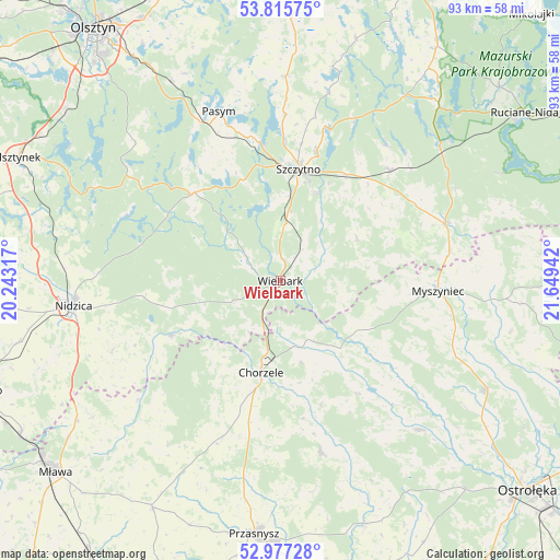
Wielbark GPS coordinates[2]
53° 23' 54.888" North, 20° 56' 46.644" East
| Map corner | latitude | longitude |
|---|---|---|
| Upper-left | 53.81575°, | 20.24317° |
| Center: | 53.39858°, | 20.94629° |
| Lower-right: | 52.97728°, | 21.64942° |
| Map W x H: | 93.2×93.2 km | = 57.9×57.9mi |
| max Lat: | 54.83135° ⇑11.5% North |
| Wielbark: | 53.39858° |
| min Lat: | ⇓88.5% South 49.21328° |
| min Long | Wielbark | max Long |
| 14.20249° | 20.94629° | 24.03723° |
| W 71.5%⇐ | ⇒28.5% E |
Elevation
Elevation of Wielbark is 125 m = 410 ft, and this is 66.4 m = 218 ft below average elevation for this country.
| Max E: |
974 m = 3196 ft | 68.2% |
| Avg. | 191.4 m = 628 ft | |
| Wielbark | 125 m = 410 ft | |
Min E: |
-3 m = -10 ft | 31.8% |
See also: Poland elevation on elevation.city.
Geographical zone
Wielbark is located in North temperate zone (between Tropic of Cancer and the Arctic Circle). Distance of this North polar circle is 1463.8 km =909.6 mi to North.| Distance of | km | miles | from Wielbark |
|---|---|---|---|
| North Pole | 4069.7 | 2528.8 | to North |
| Arctic Circle | 1463.8 | 909.6 | to North |
| Tropic Cancer | 3331.4 | 2070 | to South |
| Equator | 5937.4 | 3689.3 | to South |


Nearby cities:
15 places around Wielbark: (largest is in red/bold)
• Baranowo
34.1 km =21.2 mi,  136°
136°
• Chorzele
15.7 km =9.8 mi,  191°
191°
• Czarnia
17.2 km =10.7 mi,  105°
105°
• Dzierzgowo
33.2 km =20.6 mi,  214°
214°
• Dźwierzuty
34.1 km =21.2 mi,  1°
1°
• Jabłonka
27.9 km =17.3 mi,  293°
293°
• Janowo
20.4 km =12.7 mi,  243°
243°
• Jednorożec
29.5 km =18.3 mi,  166°
166°
• Jedwabno
20.6 km =12.8 mi,  315°
315°
• Krzynowłoga Mała
28.8 km =17.9 mi,  201°
201°
• Myszyniec
26.8 km =16.7 mi,  94°
94°
• Pasym
29.8 km =18.5 mi,  339°
339°
• Rozogi
29.2 km =18.1 mi,  70°
70°
• Szczytno
18.4 km =11.4 mi,  8°
8°
• Świętajno
25.8 km =16 mi,  43°
43°
Sources, notices
• [Note1] Compared only with cities in Poland existing in our database
• [Src1] Map data: © OpenStreetMap contributors (CC-BY-SA)
• [Src2] Other city data from geonames.org with taken over terms of usage.
• [Src3] Geographical zone / Annual Mean Temperature by Robert A. Rohde @ Wikipedia
