Szczytno geodata
Szczytno (Warmia-Masuria) is a seat of a third-order administrative division; located in Poland in Europe/Warsaw (GMT+2) time zone. With population of 26,044 people, there are 187 cities with bigger population in this country. Compared to other cities in Poland, 90.3% of cities are located further ↓South; 72.5% of cities are located further ←West and 61.1% of cities have higher elevation than Szczytno. Note1


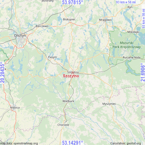
Szczytno GPS coordinates[2]
53° 33' 45.324" North, 20° 59' 14.892" East
| Map corner | latitude | longitude |
|---|---|---|
| Upper-left | 53.97815°, | 20.28435° |
| Center: | 53.56259°, | 20.98747° |
| Lower-right: | 53.14291°, | 21.6906° |
| Map W x H: | 92.9×92.9 km | = 57.7×57.7mi |
| max Lat: | 54.83135° ⇑9.7% North |
| Szczytno: | 53.56259° |
| min Lat: | ⇓90.3% South 49.21328° |
| min Long | Szczytno | max Long |
| 14.20249° | 20.98747° | 24.03723° |
| W 72.5%⇐ | ⇒27.5% E |
Elevation
Elevation of Szczytno is 144 m = 472 ft, and this is 47.4 m = 156 ft below average elevation for this country.
| Max E: |
974 m = 3196 ft | 61.1% |
| Avg. | 191.4 m = 628 ft | |
| Szczytno | 144 m = 472 ft | |
Min E: |
-3 m = -10 ft | 38.9% |
See also: Poland elevation on elevation.city.
Geographical zone
Szczytno is located in North temperate zone (between Tropic of Cancer and the Arctic Circle). Distance of this North polar circle is 1445.6 km =898.3 mi to North.| Distance of | km | miles | from Szczytno |
|---|---|---|---|
| North Pole | 4051.5 | 2517.5 | to North |
| Arctic Circle | 1445.6 | 898.3 | to North |
| Tropic Cancer | 3349.7 | 2081.4 | to South |
| Equator | 5955.6 | 3700.6 | to South |


Nearby cities:
15 places around Szczytno: (largest is in red/bold)
• Biskupiec
33.6 km =20.9 mi,  356°
356°
• Chorzele
34.1 km =21.2 mi,  190°
190°
• Czarnia
26.8 km =16.7 mi,  149°
149°
• Dźwierzuty
15.9 km =9.9 mi,  353°
353°
• Jabłonka
29.3 km =18.2 mi,  255°
255°
• Janowo
34.5 km =21.4 mi,  217°
217°
• Jedwabno
17.6 km =10.9 mi, 258°
• Myszyniec
31.4 km =19.5 mi,  130°
130°
• Pasym
16.2 km =10.1 mi,  307°
307°
• Piecki
31.7 km =19.7 mi,  46°
46°
• Purda
24.6 km =15.3 mi, 311°
• Rozogi
26.2 km =16.3 mi,  109°
109°
• Sorkwity
33 km =20.5 mi,  17°
17°
• Wielbark
18.4 km =11.4 mi, 188°
• Świętajno
15.1 km =9.4 mi,  88°
88°
Sources, notices
• [Note1] Compared only with cities in Poland existing in our database
• [Src1] Map data: © OpenStreetMap contributors (CC-BY-SA)
• [Src2] Other city data from geonames.org with taken over terms of usage.
• [Src3] Geographical zone / Annual Mean Temperature by Robert A. Rohde @ Wikipedia
