Ruciane-Nida geodata
Ruciane-Nida (Warmia-Masuria) is a seat of a third-order administrative division; located in Poland in Europe/Warsaw (GMT+2) time zone. With population of 4,722 people, there are 711 cities with bigger population in this country. Compared to other cities in Poland, 90.9% of cities are located further ↓South; 79.4% of cities are located further ←West and 65.6% of cities have higher elevation than Ruciane-Nida. Note1


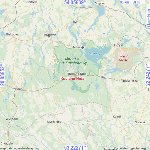
Ruciane-Nida GPS coordinates[2]
53° 38' 29.796" North, 21° 32' 22.704" East
| Map corner | latitude | longitude |
|---|---|---|
| Upper-left | 54.05639°, | 20.83652° |
| Center: | 53.64161°, | 21.53964° |
| Lower-right: | 53.22271°, | 22.24277° |
| Map W x H: | 92.7×92.7 km | = 57.6×57.6mi |
| max Lat: | 54.83135° ⇑9.1% North |
| Ruciane-Nida: | 53.64161° |
| min Lat: | ⇓90.9% South 49.21328° |
| min Long | Ruciane-Nida | max Long |
| 14.20249° | 21.53964° | 24.03723° |
| W 79.4%⇐ | ⇒20.6% E |
Elevation
Elevation of Ruciane-Nida is 131 m = 430 ft, and this is 60.4 m = 198 ft below average elevation for this country.
| Max E: |
974 m = 3196 ft | 65.6% |
| Avg. | 191.4 m = 628 ft | |
| Ruciane-Nida | 131 m = 430 ft | |
Min E: |
-3 m = -10 ft | 34.4% |
See also: Poland elevation on elevation.city.
Geographical zone
Ruciane-Nida is located in North temperate zone (between Tropic of Cancer and the Arctic Circle). Distance of this North polar circle is 1436.8 km =892.8 mi to North.| Distance of | km | miles | from Ruciane-Nida |
|---|---|---|---|
| North Pole | 4042.7 | 2512 | to North |
| Arctic Circle | 1436.8 | 892.8 | to North |
| Tropic Cancer | 3358.5 | 2086.9 | to South |
| Equator | 5964.4 | 3706.1 | to South |


Nearby cities:
15 places around Ruciane-Nida: (largest is in red/bold)
• Baranowo
21.4 km =13.3 mi,  343°
343°
• Biała Piska
34.7 km =21.6 mi,  95°
95°
• Kolno
36.3 km =22.6 mi,  134°
134°
• Mikołajki
18 km =11.2 mi,  6°
6°
• Mrągowo
29.2 km =18.1 mi,  328°
328°
• Myszyniec
31.6 km =19.6 mi,  203°
203°
• Orzysz
32.7 km =20.3 mi,  55°
55°
• Piecki
18.5 km =11.5 mi,  314°
314°
• Pisz
18.1 km =11.2 mi, 95°
• Rozogi
20.9 km =13 mi,  214°
214°
• Ryn
32.9 km =20.4 mi,  0°
0°
• Sorkwity
34.7 km =21.6 mi, 310°
• Szczytno
37.5 km =23.3 mi,  256°
256°
• Łyse
30.9 km =19.2 mi,  176°
176°
• Świętajno
22.9 km =14.2 mi,  248°
248°
Sources, notices
• [Note1] Compared only with cities in Poland existing in our database
• [Src1] Map data: © OpenStreetMap contributors (CC-BY-SA)
• [Src2] Other city data from geonames.org with taken over terms of usage.
• [Src3] Geographical zone / Annual Mean Temperature by Robert A. Rohde @ Wikipedia
