Promna geodata
Promna (Mazovia) is a seat of a third-order administrative division; located in Poland in Europe/Warsaw (GMT+2) time zone. With population of 333 people, there are 3614 cities with bigger population in this country. Compared to other cities in Poland, 59.7% of cities are located further ↓South; 71.9% of cities are located further ←West and 71.6% of cities have higher elevation than Promna. Note1


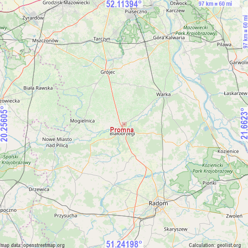
Promna GPS coordinates[2]
51° 40' 48.216" North, 20° 57' 33.012" East
| Map corner | latitude | longitude |
|---|---|---|
| Upper-left | 52.11394°, | 20.25605° |
| Center: | 51.68006°, | 20.95917° |
| Lower-right: | 51.24198°, | 21.6623° |
| Map W x H: | 97×97 km | = 60.3×60.3mi |
| max Lat: | 54.83135° ⇑40.3% North |
| Promna: | 51.68006° |
| min Lat: | ⇓59.7% South 49.21328° |
| min Long | Promna | max Long |
| 14.20249° | 20.95917° | 24.03723° |
| W 71.9%⇐ | ⇒28.1% E |
Elevation
Elevation of Promna is 118 m = 387 ft, and this is 73.4 m = 241 ft below average elevation for this country.
| Max E: |
974 m = 3196 ft | 71.6% |
| Avg. | 191.4 m = 628 ft | |
| Promna | 118 m = 387 ft | |
Min E: |
-3 m = -10 ft | 28.4% |
See also: Poland elevation on elevation.city.
Geographical zone
Promna is located in North temperate zone (between Tropic of Cancer and the Arctic Circle). Distance of this North polar circle is 1654.9 km =1028.3 mi to North.| Distance of | km | miles | from Promna |
|---|---|---|---|
| North Pole | 4260.8 | 2647.5 | to North |
| Arctic Circle | 1654.9 | 1028.3 | to North |
| Tropic Cancer | 3140.4 | 1951.4 | to South |
| Equator | 5746.3 | 3570.6 | to South |


Nearby cities:
15 places around Promna: (largest is in red/bold)
• Belsk Duży
19.2 km =11.9 mi,  327°
327°
• Białobrzegi
3.7 km =2.3 mi,  189°
189°
• Błędów
21 km =13 mi,  301°
301°
• Goszczyn
9.4 km =5.8 mi,  307°
307°
• Grójec
21.2 km =13.2 mi,  342°
342°
• Jasieniec
15.7 km =9.8 mi,  355°
355°
• Mogielnica
16.4 km =10.2 mi,  275°
275°
• Podlesie Duże
14.6 km =9.1 mi,  112°
112°
• Przybyszew
7.6 km =4.7 mi,  255°
255°
• Radzanów
15.1 km =9.4 mi,  205°
205°
• Stara Błotnica
14.9 km =9.3 mi,  175°
175°
• Stromiec
9.9 km =6.2 mi, 111°
• Sucha
6.7 km =4.2 mi, 186°
• Warka
19.7 km =12.2 mi,  54°
54°
• Wyśmierzyce
11.7 km =7.3 mi,  238°
238°
Sources, notices
• [Note1] Compared only with cities in Poland existing in our database
• [Src1] Map data: © OpenStreetMap contributors (CC-BY-SA)
• [Src2] Other city data from geonames.org with taken over terms of usage.
• [Src3] Geographical zone / Annual Mean Temperature by Robert A. Rohde @ Wikipedia
