Białobrzegi geodata
Białobrzegi (Mazovia) is a seat of a second-order administrative division; located in Poland in Europe/Warsaw (GMT+2) time zone. With population of 7,328 people, there are 523 cities with bigger population in this country. Compared to other cities in Poland, 59.1% of cities are located further ↓South; 71.7% of cities are located further ←West and 73.5% of cities have higher elevation than Białobrzegi. Note1


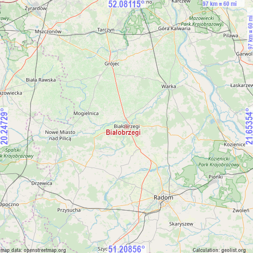
Białobrzegi GPS coordinates[2]
51° 38' 49.02" North, 20° 57' 1.476" East
| Map corner | latitude | longitude |
|---|---|---|
| Upper-left | 52.08115°, | 20.24729° |
| Center: | 51.64695°, | 20.95041° |
| Lower-right: | 51.20856°, | 21.65354° |
| Map W x H: | 97×97 km | = 60.3×60.3mi |
| max Lat: | 54.83135° ⇑40.9% North |
| Białobrzegi: | 51.64695° |
| min Lat: | ⇓59.1% South 49.21328° |
| min Long | Białobrzegi | max Long |
| 14.20249° | 20.95041° | 24.03723° |
| W 71.7%⇐ | ⇒28.3% E |
Elevation
Elevation of Białobrzegi is 114 m = 374 ft, and this is 77.4 m = 254 ft below average elevation for this country.
| Max E: |
974 m = 3196 ft | 73.5% |
| Avg. | 191.4 m = 628 ft | |
| Białobrzegi | 114 m = 374 ft | |
Min E: |
-3 m = -10 ft | 26.5% |
See also: Poland elevation on elevation.city.
Geographical zone
Białobrzegi is located in North temperate zone (between Tropic of Cancer and the Arctic Circle). Distance of this North polar circle is 1658.6 km =1030.6 mi to North.| Distance of | km | miles | from Białobrzegi |
|---|---|---|---|
| North Pole | 4264.5 | 2649.8 | to North |
| Arctic Circle | 1658.6 | 1030.6 | to North |
| Tropic Cancer | 3136.7 | 1949.1 | to South |
| Equator | 5742.6 | 3568.3 | to South |


Nearby cities:
15 places around Białobrzegi: (largest is in red/bold)
• Belsk Duży
22.1 km =13.7 mi,  333°
333°
• Goszczyn
11.6 km =7.2 mi,  324°
324°
• Jasieniec
19.4 km =12.1 mi,  358°
358°
• Jedlińsk
18.7 km =11.6 mi,  142°
142°
• Mogielnica
16.6 km =10.3 mi,  288°
288°
• Podlesie Duże
14.2 km =8.8 mi,  98°
98°
• Potworów
22 km =13.7 mi,  225°
225°
• Promna
3.7 km =2.3 mi,  9°
9°
• Przybyszew
7 km =4.3 mi,  284°
284°
• Przytyk
20.4 km =12.7 mi,  188°
188°
• Radzanów
11.6 km =7.2 mi,  211°
211°
• Stara Błotnica
11.3 km =7 mi,  171°
171°
• Stromiec
9.8 km =6.1 mi,  89°
89°
• Sucha
3 km =1.9 mi,  182°
182°
• Wyśmierzyce
9.7 km =6 mi,  255°
255°
Sources, notices
• [Note1] Compared only with cities in Poland existing in our database
• [Src1] Map data: © OpenStreetMap contributors (CC-BY-SA)
• [Src2] Other city data from geonames.org with taken over terms of usage.
• [Src3] Geographical zone / Annual Mean Temperature by Robert A. Rohde @ Wikipedia
