Stąporków geodata
Stąporków (Świętokrzyskie) is a seat of a third-order administrative division; located in Poland in Europe/Warsaw (GMT+2) time zone. With population of 5,946 people, there are 610 cities with bigger population in this country. Compared to other cities in Poland, 51.1% of cities are located further ↑North; 65.9% of cities are located further ←West and 80.6% of cities have lower elevation than Stąporków. Note1


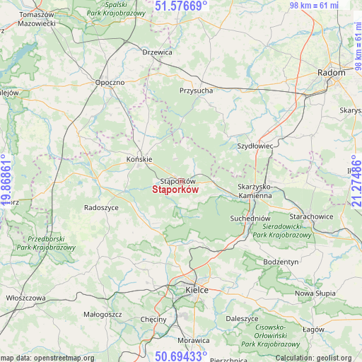
Stąporków GPS coordinates[2]
51° 8' 15.432" North, 20° 34' 18.228" East
| Map corner | latitude | longitude |
|---|---|---|
| Upper-left | 51.57669°, | 19.86861° |
| Center: | 51.13762°, | 20.57173° |
| Lower-right: | 50.69433°, | 21.27486° |
| Map W x H: | 98.1×98.1 km | = 61×61mi |
| max Lat: | 54.83135° ⇑51.1% North |
| Stąporków: | 51.13762° |
| min Lat: | ⇓48.9% South 49.21328° |
| min Long | Stąporków | max Long |
| 14.20249° | 20.57173° | 24.03723° |
| W 65.9%⇐ | ⇒34.1% E |
Elevation
Elevation of Stąporków is 268 m = 879 ft, and this is 76.6 m = 251 ft above average elevation for this country.
| Max E: |
974 m = 3196 ft | 19.4% |
| Stąporków | 268 m 879 ft | |
| Avg. | 191.4 m = 628 ft | |
Min E: |
-3 m = -10 ft | 80.6% |
See also: Poland elevation on elevation.city.
Geographical zone
Stąporków is located in North temperate zone (between Tropic of Cancer and the Arctic Circle). Distance of this North polar circle is 1715.2 km =1065.8 mi to North.| Distance of | km | miles | from Stąporków |
|---|---|---|---|
| North Pole | 4321.1 | 2685 | to North |
| Arctic Circle | 1715.2 | 1065.8 | to North |
| Tropic Cancer | 3080.1 | 1913.9 | to South |
| Equator | 5686 | 3533.1 | to South |


Nearby cities:
15 places around Stąporków: (largest is in red/bold)
• Bliżyn
13.5 km =8.4 mi,  104°
104°
• Chlewiska
18.1 km =11.2 mi,  49°
49°
• Gowarczów
18.2 km =11.3 mi,  329°
329°
• Kaniów
18.1 km =11.2 mi,  159°
159°
• Końskie
13 km =8.1 mi,  297°
297°
• Mniów
15.2 km =9.4 mi,  203°
203°
• Oblęgórek
21.3 km =13.2 mi, 196°
• Pawłów
21.3 km =13.2 mi, 52°
• Rogów
12.1 km =7.5 mi,  307°
307°
• Skarżysko-Kamienna
21.1 km =13.1 mi, 97°
• Smyków
15.8 km =9.8 mi,  229°
229°
• Suchedniów
20.6 km =12.8 mi,  119°
119°
• Wielka Wieś
5.9 km =3.7 mi,  13°
13°
• Zagnańsk
18.6 km =11.6 mi, 159°
• Świerczów
4.8 km =3 mi, 121°
Sources, notices
• [Note1] Compared only with cities in Poland existing in our database
• [Src1] Map data: © OpenStreetMap contributors (CC-BY-SA)
• [Src2] Other city data from geonames.org with taken over terms of usage.
• [Src3] Geographical zone / Annual Mean Temperature by Robert A. Rohde @ Wikipedia
