Radoszyce geodata
Radoszyce (Świętokrzyskie) is a seat of a third-order administrative division; located in Poland in Europe/Warsaw (GMT+2) time zone. With population of 3,400 people, there are 934 cities with bigger population in this country. Compared to other cities in Poland, 53.4% of cities are located further ↑North; 62% of cities are located further ←West and 72.4% of cities have lower elevation than Radoszyce. Note1


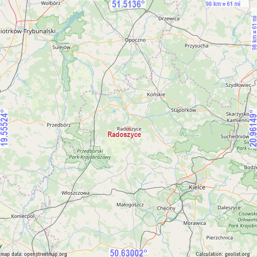
Radoszyce GPS coordinates[2]
51° 4' 26.112" North, 20° 15' 30.096" East
| Map corner | latitude | longitude |
|---|---|---|
| Upper-left | 51.5136°, | 19.55524° |
| Center: | 51.07392°, | 20.25836° |
| Lower-right: | 50.63002°, | 20.96149° |
| Map W x H: | 98.2×98.2 km | = 61×61mi |
| max Lat: | 54.83135° ⇑53.4% North |
| Radoszyce: | 51.07392° |
| min Lat: | ⇓46.6% South 49.21328° |
| min Long | Radoszyce | max Long |
| 14.20249° | 20.25836° | 24.03723° |
| W 62%⇐ | ⇒38% E |
Elevation
Elevation of Radoszyce is 237 m = 778 ft, and this is 45.6 m = 150 ft above average elevation for this country.
| Max E: |
974 m = 3196 ft | 27.6% |
| Radoszyce | 237 m 778 ft | |
| Avg. | 191.4 m = 628 ft | |
Min E: |
-3 m = -10 ft | 72.4% |
See also: Poland elevation on elevation.city.
Geographical zone
Radoszyce is located in North temperate zone (between Tropic of Cancer and the Arctic Circle). Distance of this North polar circle is 1722.3 km =1070.2 mi to North.| Distance of | km | miles | from Radoszyce |
|---|---|---|---|
| North Pole | 4328.2 | 2689.4 | to North |
| Arctic Circle | 1722.3 | 1070.2 | to North |
| Tropic Cancer | 3073 | 1909.5 | to South |
| Equator | 5678.9 | 3528.7 | to South |


Nearby cities:
15 places around Radoszyce: (largest is in red/bold)
• Białaczów
25.1 km =15.6 mi,  6°
6°
• Czermno
16.7 km =10.4 mi,  283°
283°
• Fałków
12.7 km =7.9 mi,  303°
303°
• Końskie
16.7 km =10.4 mi,  38°
38°
• Krasocin
22.8 km =14.2 mi,  205°
205°
• Mniów
17.2 km =10.7 mi,  113°
113°
• Oblęgórek
20.7 km =12.9 mi,  130°
130°
• Rogów
19 km =11.8 mi, 40°
• Ruda Maleniecka
8.4 km =5.2 mi,  343°
343°
• Smyków
10.4 km =6.5 mi, 108°
• Strawczyn
18.6 km =11.6 mi,  142°
142°
• Stąporków
23 km =14.3 mi,  72°
72°
• Słupia
10.6 km =6.6 mi,  230°
230°
• Łopuszno
13.9 km =8.6 mi,  182°
182°
• Żarnów
20 km =12.4 mi, 343°
Sources, notices
• [Note1] Compared only with cities in Poland existing in our database
• [Src1] Map data: © OpenStreetMap contributors (CC-BY-SA)
• [Src2] Other city data from geonames.org with taken over terms of usage.
• [Src3] Geographical zone / Annual Mean Temperature by Robert A. Rohde @ Wikipedia
