Krasnosielc geodata
Krasnosielc (Mazovia) is a seat of a third-order administrative division; located in Poland in Europe/Warsaw (GMT+2) time zone. With population of 1,300 people, there are 2055 cities with bigger population in this country. Compared to other cities in Poland, 84.1% of cities are located further ↓South; 75.2% of cities are located further ←West and 76% of cities have higher elevation than Krasnosielc. Note1


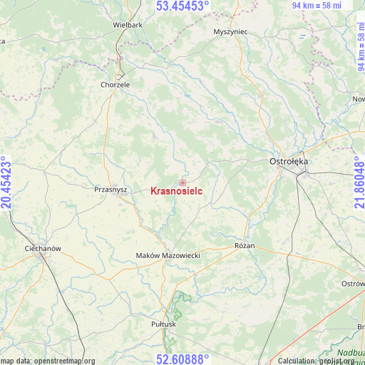
Krasnosielc GPS coordinates[2]
53° 2' 1.608" North, 21° 9' 26.46" East
| Map corner | latitude | longitude |
|---|---|---|
| Upper-left | 53.45453°, | 20.45423° |
| Center: | 53.03378°, | 21.15735° |
| Lower-right: | 52.60888°, | 21.86048° |
| Map W x H: | 94×94 km | = 58.4×58.4mi |
| max Lat: | 54.83135° ⇑15.9% North |
| Krasnosielc: | 53.03378° |
| min Lat: | ⇓84.1% South 49.21328° |
| min Long | Krasnosielc | max Long |
| 14.20249° | 21.15735° | 24.03723° |
| W 75.2%⇐ | ⇒24.8% E |
Elevation
Elevation of Krasnosielc is 108 m = 354 ft, and this is 83.4 m = 274 ft below average elevation for this country.
| Max E: |
974 m = 3196 ft | 76% |
| Avg. | 191.4 m = 628 ft | |
| Krasnosielc | 108 m = 354 ft | |
Min E: |
-3 m = -10 ft | 24% |
See also: Poland elevation on elevation.city.
Geographical zone
Krasnosielc is located in North temperate zone (between Tropic of Cancer and the Arctic Circle). Distance of this North polar circle is 1504.4 km =934.8 mi to North.| Distance of | km | miles | from Krasnosielc |
|---|---|---|---|
| North Pole | 4110.3 | 2554 | to North |
| Arctic Circle | 1504.4 | 934.8 | to North |
| Tropic Cancer | 3290.9 | 2044.9 | to South |
| Equator | 5896.8 | 3664.1 | to South |


Nearby cities:
15 places around Krasnosielc: (largest is in red/bold)
• Baranowo
18.3 km =11.4 mi,  30°
30°
• Czerwonka
16.2 km =10.1 mi,  166°
166°
• Jednorożec
13.9 km =8.6 mi,  329°
329°
• Karniewo
24.6 km =15.3 mi,  207°
207°
• Krasne
17.6 km =10.9 mi,  226°
226°
• Krzynowłoga Mała
28.4 km =17.6 mi,  299°
299°
• Maków Mazowiecki
19.2 km =11.9 mi,  191°
191°
• Młynarze
19.2 km =11.9 mi,  117°
117°
• Olszewo Borki
25.6 km =15.9 mi,  81°
81°
• Przasnysz
18.6 km =11.6 mi,  264°
264°
• Płoniawy-Bramura
8.5 km =5.3 mi,  222°
222°
• Rzewnie
25.2 km =15.7 mi,  151°
151°
• Różan
22.6 km =14 mi,  136°
136°
• Sypniewo
10.5 km =6.5 mi,  107°
107°
• Szelków
22.5 km =14 mi, 169°
Sources, notices
• [Note1] Compared only with cities in Poland existing in our database
• [Src1] Map data: © OpenStreetMap contributors (CC-BY-SA)
• [Src2] Other city data from geonames.org with taken over terms of usage.
• [Src3] Geographical zone / Annual Mean Temperature by Robert A. Rohde @ Wikipedia
