Płoniawy-Bramura geodata
Płoniawy-Bramura (Mazovia) is a seat of a third-order administrative division; located in Poland in Europe/Warsaw (GMT+2) time zone. With population of 359 people, there are 3604 cities with bigger population in this country. Compared to other cities in Poland, 83.3% of cities are located further ↓South; 74% of cities are located further ←West and 74.5% of cities have higher elevation than Płoniawy-Bramura. Note1


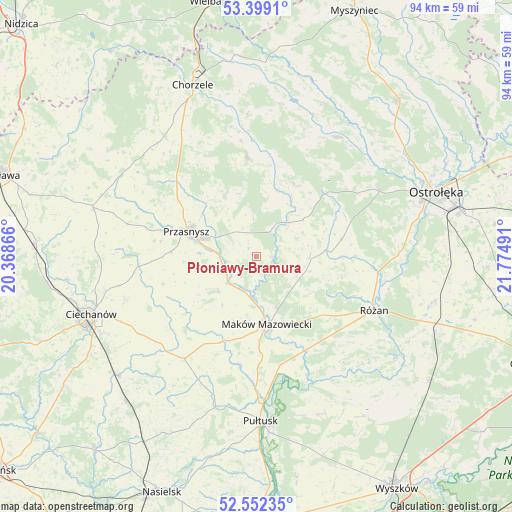
Płoniawy-Bramura GPS coordinates[2]
52° 58' 40.08" North, 21° 4' 18.408" East
| Map corner | latitude | longitude |
|---|---|---|
| Upper-left | 53.3991°, | 20.36866° |
| Center: | 52.9778°, | 21.07178° |
| Lower-right: | 52.55235°, | 21.77491° |
| Map W x H: | 94.1×94.1 km | = 58.5×58.5mi |
| max Lat: | 54.83135° ⇑16.7% North |
| Płoniawy-Bramura: | 52.9778° |
| min Lat: | ⇓83.3% South 49.21328° |
| min Long | Płoniawy-Bramu | max Long |
| 14.20249° | 21.07178° | 24.03723° |
| W 74%⇐ | ⇒26% E |
Elevation
Elevation of Płoniawy-Bramura is 112 m = 367 ft, and this is 79.4 m = 260 ft below average elevation for this country.
| Max E: |
974 m = 3196 ft | 74.5% |
| Avg. | 191.4 m = 628 ft | |
| Płoniawy-Bramura | 112 m = 367 ft | |
Min E: |
-3 m = -10 ft | 25.5% |
See also: Poland elevation on elevation.city.
Geographical zone
Płoniawy-Bramura is located in North temperate zone (between Tropic of Cancer and the Arctic Circle). Distance of this North polar circle is 1510.6 km =938.6 mi to North.| Distance of | km | miles | from Płoniawy-Bramura |
|---|---|---|---|
| North Pole | 4116.5 | 2557.9 | to North |
| Arctic Circle | 1510.6 | 938.6 | to North |
| Tropic Cancer | 3284.7 | 2041 | to South |
| Equator | 5890.6 | 3660.2 | to South |


Nearby cities:
15 places around Płoniawy-Bramura: (largest is in red/bold)
• Czernice Borowe
24.3 km =15.1 mi,  284°
284°
• Czerwonka
13.5 km =8.4 mi,  134°
134°
• Gołymin-Ośrodek
23.1 km =14.4 mi,  215°
215°
• Jednorożec
18.2 km =11.3 mi,  355°
355°
• Karniewo
16.6 km =10.3 mi,  199°
199°
• Krasne
9.2 km =5.7 mi,  229°
229°
• Krasnosielc
8.5 km =5.3 mi,  42°
42°
• Maków Mazowiecki
12.7 km =7.9 mi,  171°
171°
• Młynarze
22.9 km =14.2 mi,  96°
96°
• Opinogóra Górna
25 km =15.5 mi,  251°
251°
• Przasnysz
13.6 km =8.5 mi,  289°
289°
• Rzewnie
23.8 km =14.8 mi, 131°
• Różan
23.6 km =14.7 mi,  115°
115°
• Sypniewo
16.1 km =10 mi,  78°
78°
• Szelków
18.7 km =11.6 mi,  148°
148°
Sources, notices
• [Note1] Compared only with cities in Poland existing in our database
• [Src1] Map data: © OpenStreetMap contributors (CC-BY-SA)
• [Src2] Other city data from geonames.org with taken over terms of usage.
• [Src3] Geographical zone / Annual Mean Temperature by Robert A. Rohde @ Wikipedia
