Sorkwity geodata
Sorkwity (Warmia-Masuria) is a populated place; located in Poland in Europe/Warsaw (GMT+2) time zone. With population of 770 people, there are 2920 cities with bigger population in this country. Compared to other cities in Poland, 92.8% of cities are located further ↓South; 75% of cities are located further ←West and 64.4% of cities have higher elevation than Sorkwity. Note1


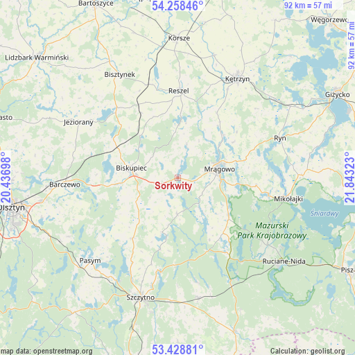
Sorkwity GPS coordinates[2]
53° 50' 44.484" North, 21° 8' 24.36" East
| Map corner | latitude | longitude |
|---|---|---|
| Upper-left | 54.25846°, | 20.43698° |
| Center: | 53.84569°, | 21.1401° |
| Lower-right: | 53.42881°, | 21.84323° |
| Map W x H: | 92.2×92.2 km | = 57.3×57.3mi |
| max Lat: | 54.83135° ⇑7.2% North |
| Sorkwity: | 53.84569° |
| min Lat: | ⇓92.8% South 49.21328° |
| min Long | Sorkwity | max Long |
| 14.20249° | 21.1401° | 24.03723° |
| W 75%⇐ | ⇒25% E |
Elevation
Elevation of Sorkwity is 135 m = 443 ft, and this is 56.4 m = 185 ft below average elevation for this country.
| Max E: |
974 m = 3196 ft | 64.4% |
| Avg. | 191.4 m = 628 ft | |
| Sorkwity | 135 m = 443 ft | |
Min E: |
-3 m = -10 ft | 35.6% |
See also: Poland elevation on elevation.city.
Geographical zone
Sorkwity is located in North temperate zone (between Tropic of Cancer and the Arctic Circle). Distance of this North polar circle is 1414.1 km =878.7 mi to North.| Distance of | km | miles | from Sorkwity |
|---|---|---|---|
| North Pole | 4020 | 2497.9 | to North |
| Arctic Circle | 1414.1 | 878.7 | to North |
| Tropic Cancer | 3381.2 | 2101 | to South |
| Equator | 5987.1 | 3720.2 | to South |


Nearby cities:
15 places around Sorkwity: (largest is in red/bold)
• Baranowo
20.3 km =12.6 mi,  96°
96°
• Barczewo
29.5 km =18.3 mi,  266°
266°
• Biskupiec
12.2 km =7.6 mi,  279°
279°
• Bisztynek
31 km =19.3 mi,  329°
329°
• Czerwonka
17.8 km =11.1 mi,  296°
296°
• Dźwierzuty
19.6 km =12.2 mi,  217°
217°
• Jeziorany
29.6 km =18.4 mi, 299°
• Kolno
19.3 km =12 mi, 330°
• Kętrzyn
29.9 km =18.6 mi,  30°
30°
• Mikołajki
28.6 km =17.8 mi, 99°
• Mrągowo
11 km =6.8 mi,  79°
79°
• Piecki
16.3 km =10.1 mi,  126°
126°
• Reszel
22.8 km =14.2 mi,  0°
0°
• Ryn
28.5 km =17.7 mi,  68°
68°
• Świętajno
31.4 km =19.5 mi,  170°
170°
Sources, notices
• [Note1] Compared only with cities in Poland existing in our database
• [Src1] Map data: © OpenStreetMap contributors (CC-BY-SA)
• [Src2] Other city data from geonames.org with taken over terms of usage.
• [Src3] Geographical zone / Annual Mean Temperature by Robert A. Rohde @ Wikipedia
