Mielno geodata
Mielno (Warmia-Masuria) is a populated place; located in Poland in Europe/Warsaw (GMT+2) time zone. With population of 540 people, there are 3429 cities with bigger population in this country. Compared to other cities in Poland, 89.7% of cities are located further ↓South; 61.1% of cities are located further ←West and 53.8% of cities have lower elevation than Mielno. Note1


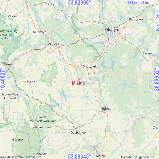
Mielno GPS coordinates[2]
53° 30' 49.032" North, 20° 11' 36.204" East
| Map corner | latitude | longitude |
|---|---|---|
| Upper-left | 53.92966°, | 19.49027° |
| Center: | 53.51362°, | 20.19339° |
| Lower-right: | 53.09345°, | 20.89652° |
| Map W x H: | 93×93 km | = 57.8×57.8mi |
| max Lat: | 54.83135° ⇑10.3% North |
| Mielno: | 53.51362° |
| min Lat: | ⇓89.7% South 49.21328° |
| min Long | Mielno | max Long |
| 14.20249° | 20.19339° | 24.03723° |
| W 61.1%⇐ | ⇒38.9% E |
Elevation
Elevation of Mielno is 182 m = 597 ft, and this is 9.4 m = 31 ft below average elevation for this country.
| Max E: |
974 m = 3196 ft | 46.2% |
| Avg. | 191.4 m = 628 ft | |
| Mielno | 182 m = 597 ft | |
Min E: |
-3 m = -10 ft | 53.8% |
See also: Poland elevation on elevation.city.
Geographical zone
Mielno is located in North temperate zone (between Tropic of Cancer and the Arctic Circle). Distance of this North polar circle is 1451 km =901.6 mi to North.| Distance of | km | miles | from Mielno |
|---|---|---|---|
| North Pole | 4056.9 | 2520.8 | to North |
| Arctic Circle | 1451 | 901.6 | to North |
| Tropic Cancer | 3344.2 | 2078 | to South |
| Equator | 5950.2 | 3697.3 | to South |


Nearby cities:
15 places around Mielno: (largest is in red/bold)
• Działdowo
30.5 km =19 mi,  182°
182°
• Dąbrówno
13.7 km =8.5 mi,  229°
229°
• Gierzwałd
7.6 km =4.7 mi,  293°
293°
• Gietrzwałd
26 km =16.2 mi,  6°
6°
• Grabowo
25.3 km =15.7 mi,  282°
282°
• Grunwald
7.3 km =4.5 mi,  243°
243°
• Jabłonka
24.2 km =15 mi,  94°
94°
• Kozłowo
23.9 km =14.9 mi,  164°
164°
• Lubawa
29.4 km =18.3 mi,  267°
267°
• Nidzica
23 km =14.3 mi,  137°
137°
• Olsztynek
9.9 km =6.2 mi,  37°
37°
• Ostróda
25.3 km =15.7 mi,  323°
323°
• Płośnica
29.4 km =18.3 mi,  204°
204°
• Rybno
22.5 km =14 mi, 230°
• Stawiguda
21 km =13 mi, 40°
Sources, notices
• [Note1] Compared only with cities in Poland existing in our database
• [Src1] Map data: © OpenStreetMap contributors (CC-BY-SA)
• [Src2] Other city data from geonames.org with taken over terms of usage.
• [Src3] Geographical zone / Annual Mean Temperature by Robert A. Rohde @ Wikipedia
