Ostróda geodata
Ostróda (Warmia-Masuria) is a seat of a second-order administrative division; located in Poland in Europe/Warsaw (GMT+2) time zone. With population of 33,524 people, there are 154 cities with bigger population in this country. Compared to other cities in Poland, 91.4% of cities are located further ↓South; 57.7% of cities are located further ←West and 75% of cities have higher elevation than Ostróda. Note1


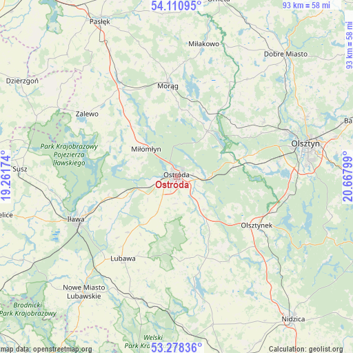
Ostróda GPS coordinates[2]
53° 41' 48.156" North, 19° 57' 53.496" East
| Map corner | latitude | longitude |
|---|---|---|
| Upper-left | 54.11095°, | 19.26174° |
| Center: | 53.69671°, | 19.96486° |
| Lower-right: | 53.27836°, | 20.66799° |
| Map W x H: | 92.6×92.6 km | = 57.5×57.5mi |
| max Lat: | 54.83135° ⇑8.6% North |
| Ostróda: | 53.69671° |
| min Lat: | ⇓91.4% South 49.21328° |
| min Long | Ostróda | max Long |
| 14.20249° | 19.96486° | 24.03723° |
| W 57.7%⇐ | ⇒42.3% E |
Elevation
Elevation of Ostróda is 111 m = 364 ft, and this is 80.4 m = 264 ft below average elevation for this country.
| Max E: |
974 m = 3196 ft | 75% |
| Avg. | 191.4 m = 628 ft | |
| Ostróda | 111 m = 364 ft | |
Min E: |
-3 m = -10 ft | 25% |
See also: Poland elevation on elevation.city.
Geographical zone
Ostróda is located in North temperate zone (between Tropic of Cancer and the Arctic Circle). Distance of this North polar circle is 1430.7 km =889 mi to North.| Distance of | km | miles | from Ostróda |
|---|---|---|---|
| North Pole | 4036.5 | 2508.2 | to North |
| Arctic Circle | 1430.7 | 889 | to North |
| Tropic Cancer | 3364.6 | 2090.7 | to South |
| Equator | 5970.5 | 3709.9 | to South |


Nearby cities:
15 places around Ostróda: (largest is in red/bold)
• Gierzwałd
19.1 km =11.9 mi,  154°
154°
• Gietrzwałd
18.8 km =11.7 mi,  72°
72°
• Grabowo
17.8 km =11.1 mi,  212°
212°
• Grunwald
25.1 km =15.6 mi,  160°
160°
• Iława
28.4 km =17.6 mi,  246°
246°
• Jonkowo
27 km =16.8 mi,  57°
57°
• Lubawa
25.7 km =16 mi, 213°
• Małdyty
28.7 km =17.8 mi,  329°
329°
• Mielno
25.3 km =15.7 mi,  143°
143°
• Miłomłyn
11.2 km =7 mi,  312°
312°
• Morąg
24.6 km =15.3 mi,  354°
354°
• Olsztynek
24.5 km =15.2 mi,  120°
120°
• Stawiguda
29 km =18 mi,  98°
98°
• Zalewo
28.8 km =17.9 mi,  304°
304°
• Łukta
14.4 km =8.9 mi,  32°
32°
Sources, notices
• [Note1] Compared only with cities in Poland existing in our database
• [Src1] Map data: © OpenStreetMap contributors (CC-BY-SA)
• [Src2] Other city data from geonames.org with taken over terms of usage.
• [Src3] Geographical zone / Annual Mean Temperature by Robert A. Rohde @ Wikipedia
