Jabłonka geodata
Jabłonka (Warmia-Masuria) is a populated place; located in Poland in Europe/Warsaw (GMT+2) time zone. With population of 780 people, there are 2898 cities with bigger population in this country. Compared to other cities in Poland, 89.6% of cities are located further ↓South; 65.8% of cities are located further ←West and 63% of cities have higher elevation than Jabłonka. Note1


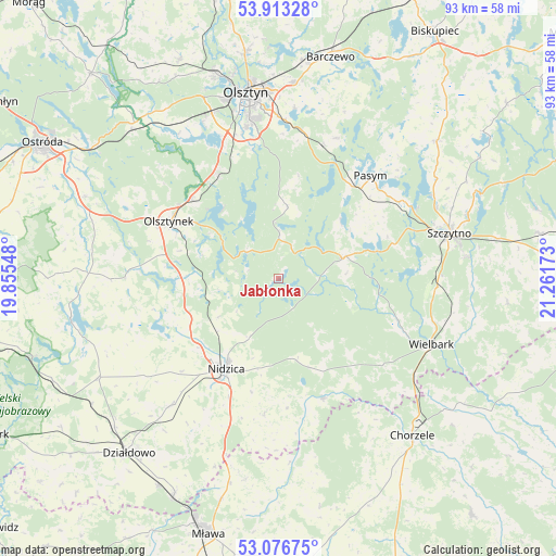
Jabłonka GPS coordinates[2]
53° 29' 49.488" North, 20° 33' 30.96" East
| Map corner | latitude | longitude |
|---|---|---|
| Upper-left | 53.91328°, | 19.85548° |
| Center: | 53.49708°, | 20.5586° |
| Lower-right: | 53.07675°, | 21.26173° |
| Map W x H: | 93×93 km | = 57.8×57.8mi |
| max Lat: | 54.83135° ⇑10.4% North |
| Jabłonka: | 53.49708° |
| min Lat: | ⇓89.6% South 49.21328° |
| min Long | Jabłonka | max Long |
| 14.20249° | 20.5586° | 24.03723° |
| W 65.8%⇐ | ⇒34.2% E |
Elevation
Elevation of Jabłonka is 139 m = 456 ft, and this is 52.4 m = 172 ft below average elevation for this country.
| Max E: |
974 m = 3196 ft | 63% |
| Avg. | 191.4 m = 628 ft | |
| Jabłonka | 139 m = 456 ft | |
Min E: |
-3 m = -10 ft | 37% |
See also: Poland elevation on elevation.city.
Geographical zone
Jabłonka is located in North temperate zone (between Tropic of Cancer and the Arctic Circle). Distance of this North polar circle is 1452.9 km =902.8 mi to North.| Distance of | km | miles | from Jabłonka |
|---|---|---|---|
| North Pole | 4058.7 | 2522 | to North |
| Arctic Circle | 1452.9 | 902.8 | to North |
| Tropic Cancer | 3342.4 | 2076.9 | to South |
| Equator | 5948.3 | 3696.1 | to South |


Nearby cities:
15 places around Jabłonka: (largest is in red/bold)
• Gierzwałd
31.5 km =19.6 mi,  278°
278°
• Grunwald
30.8 km =19.1 mi,  267°
267°
• Janowo
21.5 km =13.4 mi,  159°
159°
• Jedwabno
11.7 km =7.3 mi,  71°
71°
• Kortowo
29.7 km =18.5 mi,  346°
346°
• Kozłowo
27.6 km =17.1 mi,  219°
219°
• Mielno
24.2 km =15 mi, 274°
• Nidzica
17.5 km =10.9 mi,  209°
209°
• Olsztyn
31.7 km =19.7 mi, 352°
• Olsztynek
20.5 km =12.7 mi,  298°
298°
• Pasym
23 km =14.3 mi,  42°
42°
• Purda
25.5 km =15.8 mi,  22°
22°
• Stawiguda
20.6 km =12.8 mi,  329°
329°
• Szczytno
29.3 km =18.2 mi,  75°
75°
• Wielbark
27.9 km =17.3 mi,  113°
113°
Sources, notices
• [Note1] Compared only with cities in Poland existing in our database
• [Src1] Map data: © OpenStreetMap contributors (CC-BY-SA)
• [Src2] Other city data from geonames.org with taken over terms of usage.
• [Src3] Geographical zone / Annual Mean Temperature by Robert A. Rohde @ Wikipedia
