Jedlicze geodata
Jedlicze (Subcarpathian) is a seat of a third-order administrative division; located in Poland in Europe/Warsaw (GMT+2) time zone. With population of 5,629 people, there are 631 cities with bigger population in this country. Compared to other cities in Poland, 94.1% of cities are located further ↑North; 80.6% of cities are located further ←West and 79.4% of cities have lower elevation than Jedlicze. Note1


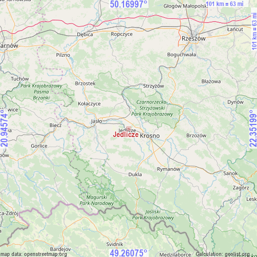
Jedlicze GPS coordinates[2]
49° 43' 2.964" North, 21° 38' 55.896" East
| Map corner | latitude | longitude |
|---|---|---|
| Upper-left | 50.16997°, | 20.94574° |
| Center: | 49.71749°, | 21.64886° |
| Lower-right: | 49.26075°, | 22.35199° |
| Map W x H: | 101.1×101.1 km | = 62.8×62.8mi |
| max Lat: | 54.83135° ⇑94.1% North |
| Jedlicze: | 49.71749° |
| min Lat: | ⇓5.9% South 49.21328° |
| min Long | Jedlicze | max Long |
| 14.20249° | 21.64886° | 24.03723° |
| W 80.6%⇐ | ⇒19.4% E |
Elevation
Elevation of Jedlicze is 263 m = 863 ft, and this is 71.6 m = 235 ft above average elevation for this country.
| Max E: |
974 m = 3196 ft | 20.6% |
| Jedlicze | 263 m 863 ft | |
| Avg. | 191.4 m = 628 ft | |
Min E: |
-3 m = -10 ft | 79.4% |
See also: Poland elevation on elevation.city.
Geographical zone
Jedlicze is located in North temperate zone (between Tropic of Cancer and the Arctic Circle). Distance of this North polar circle is 1873.1 km =1163.9 mi to North.| Distance of | km | miles | from Jedlicze |
|---|---|---|---|
| North Pole | 4479 | 2783.1 | to North |
| Arctic Circle | 1873.1 | 1163.9 | to North |
| Tropic Cancer | 2922.1 | 1815.7 | to South |
| Equator | 5528.1 | 3435 | to South |


Nearby cities:
15 places around Jedlicze: (largest is in red/bold)
• Chorkówka
8 km =5 mi,  168°
168°
• Dębowiec
14 km =8.7 mi,  254°
254°
• Frysztak
14.1 km =8.8 mi,  348°
348°
• Jasło
13 km =8.1 mi,  283°
283°
• Korczyna
11.5 km =7.1 mi,  91°
91°
• Krosno
9.3 km =5.8 mi,  110°
110°
• Krościenko Wyżne
13.6 km =8.5 mi, 108°
• Miejsce Piastowe
13.6 km =8.5 mi,  132°
132°
• Odrzykoń
7.1 km =4.4 mi,  68°
68°
• Osiek Jasielski
14.6 km =9.1 mi,  232°
232°
• Tarnowiec
5.4 km =3.4 mi,  286°
286°
• Wojaszówka
6.9 km =4.3 mi,  13°
13°
• Wysoka Strzyżowska
14.2 km =8.8 mi,  27°
27°
• Zarzecze
12.9 km =8 mi, 249°
• Łęki
10.3 km =6.4 mi,  4°
4°
Sources, notices
• [Note1] Compared only with cities in Poland existing in our database
• [Src1] Map data: © OpenStreetMap contributors (CC-BY-SA)
• [Src2] Other city data from geonames.org with taken over terms of usage.
• [Src3] Geographical zone / Annual Mean Temperature by Robert A. Rohde @ Wikipedia
