Chorkówka geodata
Chorkówka (Subcarpathian) is a seat of a third-order administrative division; located in Poland in Europe/Warsaw (GMT+2) time zone. With population of 784 people, there are 2891 cities with bigger population in this country. Compared to other cities in Poland, 95.8% of cities are located further ↑North; 80.9% of cities are located further ←West and 86.4% of cities have lower elevation than Chorkówka. Note1


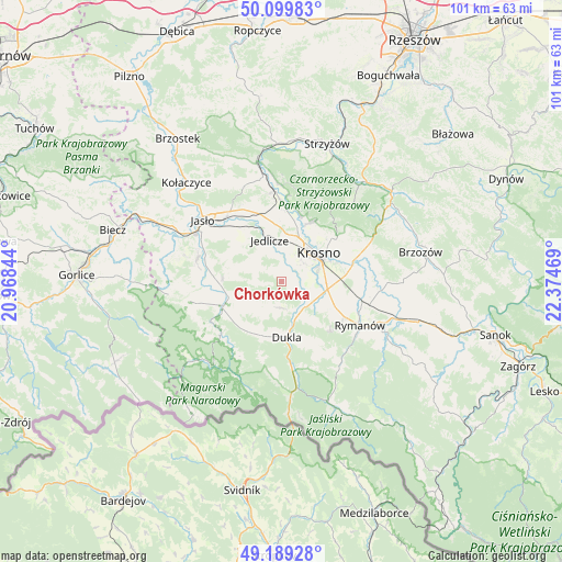
Chorkówka GPS coordinates[2]
49° 38' 48.048" North, 21° 40' 17.616" East
| Map corner | latitude | longitude |
|---|---|---|
| Upper-left | 50.09983°, | 20.96844° |
| Center: | 49.64668°, | 21.67156° |
| Lower-right: | 49.18928°, | 22.37469° |
| Map W x H: | 101.2×101.2 km | = 62.9×62.9mi |
| max Lat: | 54.83135° ⇑95.8% North |
| Chorkówka: | 49.64668° |
| min Lat: | ⇓4.2% South 49.21328° |
| min Long | Chorkówka | max Long |
| 14.20249° | 21.67156° | 24.03723° |
| W 80.9%⇐ | ⇒19.1% E |
Elevation
Elevation of Chorkówka is 298 m = 978 ft, and this is 106.6 m = 350 ft above average elevation for this country.
| Max E: |
974 m = 3196 ft | 13.6% |
| Chorkówka | 298 m 978 ft | |
| Avg. | 191.4 m = 628 ft | |
Min E: |
-3 m = -10 ft | 86.4% |
See also: Poland elevation on elevation.city.
Geographical zone
Chorkówka is located in North temperate zone (between Tropic of Cancer and the Arctic Circle). Distance of this North polar circle is 1881 km =1168.8 mi to North.| Distance of | km | miles | from Chorkówka |
|---|---|---|---|
| North Pole | 4486.9 | 2788 | to North |
| Arctic Circle | 1881 | 1168.8 | to North |
| Tropic Cancer | 2914.3 | 1810.9 | to South |
| Equator | 5520.2 | 3430.1 | to South |


Nearby cities:
15 places around Chorkówka: (largest is in red/bold)
• Dukla
10.2 km =6.3 mi,  175°
175°
• Dębowiec
15.7 km =9.8 mi,  285°
285°
• Iwonicz-Zdrój
12.6 km =7.8 mi,  137°
137°
• Jedlicze
8 km =5 mi,  348°
348°
• Korczyna
12.5 km =7.8 mi,  52°
52°
• Krosno
8.5 km =5.3 mi,  56°
56°
• Krościenko Wyżne
11.9 km =7.4 mi,  72°
72°
• Miejsce Piastowe
8.4 km =5.2 mi,  99°
99°
• Nowy Żmigród
11.7 km =7.3 mi,  245°
245°
• Odrzykoń
11.6 km =7.2 mi,  25°
25°
• Osiek Jasielski
13.2 km =8.2 mi,  265°
265°
• Rymanów
16.2 km =10.1 mi,  118°
118°
• Tarnowiec
11.6 km =7.2 mi,  323°
323°
• Wojaszówka
14.6 km =9.1 mi,  359°
359°
• Zarzecze
14.1 km =8.8 mi,  283°
283°
Sources, notices
• [Note1] Compared only with cities in Poland existing in our database
• [Src1] Map data: © OpenStreetMap contributors (CC-BY-SA)
• [Src2] Other city data from geonames.org with taken over terms of usage.
• [Src3] Geographical zone / Annual Mean Temperature by Robert A. Rohde @ Wikipedia
