Odrzykoń geodata
Odrzykoń (Subcarpathian) is a populated place; located in Poland in Europe/Warsaw (GMT+2) time zone. With population of 2,950 people, there are 1072 cities with bigger population in this country. Compared to other cities in Poland, 93.3% of cities are located further ↑North; 81.5% of cities are located further ←West and 80.6% of cities have lower elevation than Odrzykoń. Note1


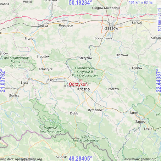
Odrzykoń GPS coordinates[2]
49° 44' 26.052" North, 21° 44' 26.664" East
| Map corner | latitude | longitude |
|---|---|---|
| Upper-left | 50.19284°, | 21.03762° |
| Center: | 49.74057°, | 21.74074° |
| Lower-right: | 49.28405°, | 22.44387° |
| Map W x H: | 101×101 km | = 62.8×62.8mi |
| max Lat: | 54.83135° ⇑93.3% North |
| Odrzykoń: | 49.74057° |
| min Lat: | ⇓6.7% South 49.21328° |
| min Long | Odrzykoń | max Long |
| 14.20249° | 21.74074° | 24.03723° |
| W 81.5%⇐ | ⇒18.5% E |
Elevation
Elevation of Odrzykoń is 268 m = 879 ft, and this is 76.6 m = 251 ft above average elevation for this country.
| Max E: |
974 m = 3196 ft | 19.4% |
| Odrzykoń | 268 m 879 ft | |
| Avg. | 191.4 m = 628 ft | |
Min E: |
-3 m = -10 ft | 80.6% |
See also: Poland elevation on elevation.city.
Geographical zone
Odrzykoń is located in North temperate zone (between Tropic of Cancer and the Arctic Circle). Distance of this North polar circle is 1870.5 km =1162.3 mi to North.| Distance of | km | miles | from Odrzykoń |
|---|---|---|---|
| North Pole | 4476.4 | 2781.5 | to North |
| Arctic Circle | 1870.5 | 1162.3 | to North |
| Tropic Cancer | 2924.7 | 1817.3 | to South |
| Equator | 5530.6 | 3436.6 | to South |


Nearby cities:
15 places around Odrzykoń: (largest is in red/bold)
• Chorkówka
11.6 km =7.2 mi,  205°
205°
• Haczów
14.3 km =8.9 mi,  127°
127°
• Jabłonica Polska
12.4 km =7.7 mi,  112°
112°
• Jasienica Rosielna
14.5 km =9 mi,  85°
85°
• Jedlicze
7.1 km =4.4 mi,  248°
248°
• Korczyna
5.7 km =3.5 mi,  119°
119°
• Krasna
9 km =5.6 mi,  64°
64°
• Krosno
6.2 km =3.9 mi,  159°
159°
• Krościenko Wyżne
9.3 km =5.8 mi,  136°
136°
• Malinówka
14.3 km =8.9 mi, 109°
• Miejsce Piastowe
12.3 km =7.6 mi, 164°
• Tarnowiec
11.8 km =7.3 mi,  264°
264°
• Wojaszówka
6.5 km =4 mi,  309°
309°
• Wysoka Strzyżowska
10 km =6.2 mi,  0°
0°
• Łęki
9.6 km =6 mi,  323°
323°
Sources, notices
• [Note1] Compared only with cities in Poland existing in our database
• [Src1] Map data: © OpenStreetMap contributors (CC-BY-SA)
• [Src2] Other city data from geonames.org with taken over terms of usage.
• [Src3] Geographical zone / Annual Mean Temperature by Robert A. Rohde @ Wikipedia
