Kozłów geodata
Kozłów (Lesser Poland) is a seat of a third-order administrative division; located in Poland in Europe/Warsaw (GMT+2) time zone. With population of 1,021 people, there are 2430 cities with bigger population in this country. Compared to other cities in Poland, 67.6% of cities are located further ↑North; 58.6% of cities are located further ←West and 84.7% of cities have lower elevation than Kozłów. Note1


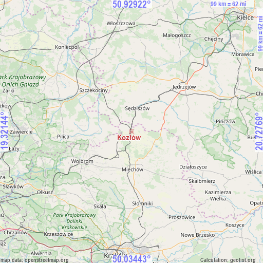
Kozłów GPS coordinates[2]
50° 29' 2.184" North, 20° 1' 28.416" East
| Map corner | latitude | longitude |
|---|---|---|
| Upper-left | 50.92922°, | 19.32144° |
| Center: | 50.48394°, | 20.02456° |
| Lower-right: | 50.03443°, | 20.72769° |
| Map W x H: | 99.5×99.5 km | = 61.8×61.8mi |
| max Lat: | 54.83135° ⇑67.6% North |
| Kozłów: | 50.48394° |
| min Lat: | ⇓32.4% South 49.21328° |
| min Long | Kozłów | max Long |
| 14.20249° | 20.02456° | 24.03723° |
| W 58.6%⇐ | ⇒41.4% E |
Elevation
Elevation of Kozłów is 288 m = 945 ft, and this is 96.6 m = 317 ft above average elevation for this country.
| Max E: |
974 m = 3196 ft | 15.3% |
| Kozłów | 288 m 945 ft | |
| Avg. | 191.4 m = 628 ft | |
Min E: |
-3 m = -10 ft | 84.7% |
See also: Poland elevation on elevation.city.
Geographical zone
Kozłów is located in North temperate zone (between Tropic of Cancer and the Arctic Circle). Distance of this North polar circle is 1787.9 km =1110.9 mi to North.| Distance of | km | miles | from Kozłów |
|---|---|---|---|
| North Pole | 4393.8 | 2730.2 | to North |
| Arctic Circle | 1787.9 | 1110.9 | to North |
| Tropic Cancer | 3007.4 | 1868.7 | to South |
| Equator | 5613.3 | 3487.9 | to South |


Nearby cities:
15 places around Kozłów: (largest is in red/bold)
• Goleniowy
19.7 km =12.2 mi,  327°
327°
• Książ Wielki
9.3 km =5.8 mi,  118°
118°
• Kępie
6.8 km =4.2 mi,  245°
245°
• Marcinowice
2.9 km =1.8 mi,  315°
315°
• Miechów
14.2 km =8.8 mi,  179°
179°
• Miechów Charsznica
11.1 km =6.9 mi,  208°
208°
• Moskorzew
19.2 km =11.9 mi,  341°
341°
• Potok Wielki
19.3 km =12 mi,  47°
47°
• Rokitno
20.5 km =12.7 mi,  303°
303°
• Szczekociny
21.2 km =13.2 mi, 318°
• Sędziszów
9.4 km =5.8 mi,  13°
13°
• Słupia
13.5 km =8.4 mi, 344°
• Wierzchowisko
19.1 km =11.9 mi,  230°
230°
• Wodzisław
12.5 km =7.8 mi,  71°
71°
• Żarnowiec
11.6 km =7.2 mi,  267°
267°
Sources, notices
• [Note1] Compared only with cities in Poland existing in our database
• [Src1] Map data: © OpenStreetMap contributors (CC-BY-SA)
• [Src2] Other city data from geonames.org with taken over terms of usage.
• [Src3] Geographical zone / Annual Mean Temperature by Robert A. Rohde @ Wikipedia
