Marcinowice geodata
Marcinowice (Lesser Poland) is a populated place; located in Poland in Europe/Warsaw (GMT+2) time zone. With population of 527 people, there are 3463 cities with bigger population in this country. Compared to other cities in Poland, 67.3% of cities are located further ↑North; 58.3% of cities are located further ←West and 83% of cities have lower elevation than Marcinowice. Note1


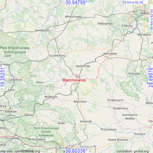
Marcinowice GPS coordinates[2]
50° 30' 10.404" North, 19° 59' 44.268" East
| Map corner | latitude | longitude |
|---|---|---|
| Upper-left | 50.94799°, | 19.29251° |
| Center: | 50.50289°, | 19.99563° |
| Lower-right: | 50.05356°, | 20.69876° |
| Map W x H: | 99.5×99.4 km | = 61.8×61.8mi |
| max Lat: | 54.83135° ⇑67.3% North |
| Marcinowice: | 50.50289° |
| min Lat: | ⇓32.7% South 49.21328° |
| min Long | Marcinowice | max Long |
| 14.20249° | 19.99563° | 24.03723° |
| W 58.3%⇐ | ⇒41.7% E |
Elevation
Elevation of Marcinowice is 280 m = 919 ft, and this is 88.6 m = 291 ft above average elevation for this country.
| Max E: |
974 m = 3196 ft | 17% |
| Marcinowice | 280 m 919 ft | |
| Avg. | 191.4 m = 628 ft | |
Min E: |
-3 m = -10 ft | 83% |
See also: Poland elevation on elevation.city.
Geographical zone
Marcinowice is located in North temperate zone (between Tropic of Cancer and the Arctic Circle). Distance of this North polar circle is 1785.8 km =1109.6 mi to North.| Distance of | km | miles | from Marcinowice |
|---|---|---|---|
| North Pole | 4391.7 | 2728.9 | to North |
| Arctic Circle | 1785.8 | 1109.6 | to North |
| Tropic Cancer | 3009.5 | 1870 | to South |
| Equator | 5615.4 | 3489.2 | to South |


Nearby cities:
15 places around Marcinowice: (largest is in red/bold)
• Goleniowy
16.8 km =10.4 mi,  329°
329°
• Kozłów
2.9 km =1.8 mi,  135°
135°
• Książ Wielki
12.2 km =7.6 mi,  122°
122°
• Kępie
6.4 km =4 mi,  220°
220°
• Miechów
16.4 km =10.2 mi,  172°
172°
• Miechów Charsznica
12.3 km =7.6 mi,  195°
195°
• Moskorzew
16.5 km =10.3 mi,  345°
345°
• Potok Wielki
19.6 km =12.2 mi,  56°
56°
• Rokitno
17.6 km =10.9 mi,  301°
301°
• Szczekociny
18.3 km =11.4 mi,  318°
318°
• Sędziszów
8.2 km =5.1 mi,  31°
31°
• Słupia
11 km =6.8 mi, 352°
• Wierzchowisko
19.1 km =11.9 mi, 221°
• Wodzisław
14 km =8.7 mi,  81°
81°
• Żarnowiec
9.9 km =6.2 mi,  254°
254°
Sources, notices
• [Note1] Compared only with cities in Poland existing in our database
• [Src1] Map data: © OpenStreetMap contributors (CC-BY-SA)
• [Src2] Other city data from geonames.org with taken over terms of usage.
• [Src3] Geographical zone / Annual Mean Temperature by Robert A. Rohde @ Wikipedia
