Białobrzegi geodata
Białobrzegi (Subcarpathian) is a seat of a third-order administrative division; located in Poland in Europe/Warsaw (GMT+2) time zone. With population of 2,200 people, there are 1362 cities with bigger population in this country. Compared to other cities in Poland, 77.8% of cities are located further ↑North; 89.2% of cities are located further ←West and 54.6% of cities have lower elevation than Białobrzegi. Note1


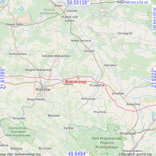
Białobrzegi GPS coordinates[2]
50° 6' 9.072" North, 22° 19' 8.652" East
| Map corner | latitude | longitude |
|---|---|---|
| Upper-left | 50.55139°, | 21.61595° |
| Center: | 50.10252°, | 22.31907° |
| Lower-right: | 49.6494°, | 23.0222° |
| Map W x H: | 100.3×100.3 km | = 62.3×62.3mi |
| max Lat: | 54.83135° ⇑77.8% North |
| Białobrzegi: | 50.10252° |
| min Lat: | ⇓22.2% South 49.21328° |
| min Long | Białobrzegi | max Long |
| 14.20249° | 22.31907° | 24.03723° |
| W 89.2%⇐ | ⇒10.8% E |
Elevation
Elevation of Białobrzegi is 184 m = 604 ft, and this is 7.4 m = 24 ft below average elevation for this country.
| Max E: |
974 m = 3196 ft | 45.4% |
| Avg. | 191.4 m = 628 ft | |
| Białobrzegi | 184 m = 604 ft | |
Min E: |
-3 m = -10 ft | 54.6% |
See also: Poland elevation on elevation.city.
Geographical zone
Białobrzegi is located in North temperate zone (between Tropic of Cancer and the Arctic Circle). Distance of this North polar circle is 1830.3 km =1137.3 mi to North.| Distance of | km | miles | from Białobrzegi |
|---|---|---|---|
| North Pole | 4436.2 | 2756.5 | to North |
| Arctic Circle | 1830.3 | 1137.3 | to North |
| Tropic Cancer | 2965 | 1842.4 | to South |
| Equator | 5570.9 | 3461.6 | to South |


Nearby cities:
15 places around Białobrzegi: (largest is in red/bold)
• Czarna
9.8 km =6.1 mi,  274°
274°
• Dębów
10.5 km =6.5 mi,  127°
127°
• Gać
8.9 km =5.5 mi,  161°
161°
• Grzęska
9.9 km =6.2 mi,  102°
102°
• Głuchów
4.1 km =2.5 mi,  235°
235°
• Kosina
3.5 km =2.2 mi,  168°
168°
• Krzemienica
10.9 km =6.8 mi,  245°
245°
• Markowa
8.5 km =5.3 mi, 173°
• Nowosielce
8.2 km =5.1 mi, 127°
• Rakszawa
8.6 km =5.3 mi,  318°
318°
• Rogóźno
5.1 km =3.2 mi, 128°
• Sonina
6 km =3.7 mi,  219°
219°
• Wysoka
7.7 km =4.8 mi,  213°
213°
• Łańcut
7.4 km =4.6 mi, 239°
• Żołynia
6.7 km =4.2 mi,  353°
353°
Sources, notices
• [Note1] Compared only with cities in Poland existing in our database
• [Src1] Map data: © OpenStreetMap contributors (CC-BY-SA)
• [Src2] Other city data from geonames.org with taken over terms of usage.
• [Src3] Geographical zone / Annual Mean Temperature by Robert A. Rohde @ Wikipedia
