Kosina geodata
Kosina (Subcarpathian) is a populated place; located in Poland in Europe/Warsaw (GMT+2) time zone. With population of 3,590 people, there are 893 cities with bigger population in this country. Compared to other cities in Poland, 79.1% of cities are located further ↑North; 89.4% of cities are located further ←West and 59.4% of cities have lower elevation than Kosina. Note1


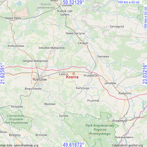
Kosina GPS coordinates[2]
50° 4' 19.668" North, 22° 19' 44.508" East
| Map corner | latitude | longitude |
|---|---|---|
| Upper-left | 50.52129°, | 21.62591° |
| Center: | 50.07213°, | 22.32903° |
| Lower-right: | 49.61872°, | 23.03216° |
| Map W x H: | 100.4×100.4 km | = 62.4×62.4mi |
| max Lat: | 54.83135° ⇑79.1% North |
| Kosina: | 50.07213° |
| min Lat: | ⇓20.9% South 49.21328° |
| min Long | Kosina | max Long |
| 14.20249° | 22.32903° | 24.03723° |
| W 89.4%⇐ | ⇒10.6% E |
Elevation
Elevation of Kosina is 199 m = 653 ft, and this is 7.6 m = 25 ft above average elevation for this country.
| Max E: |
974 m = 3196 ft | 40.6% |
| Kosina | 199 m 653 ft | |
| Avg. | 191.4 m = 628 ft | |
Min E: |
-3 m = -10 ft | 59.4% |
See also: Poland elevation on elevation.city.
Geographical zone
Kosina is located in North temperate zone (between Tropic of Cancer and the Arctic Circle). Distance of this North polar circle is 1833.7 km =1139.4 mi to North.| Distance of | km | miles | from Kosina |
|---|---|---|---|
| North Pole | 4439.6 | 2758.6 | to North |
| Arctic Circle | 1833.7 | 1139.4 | to North |
| Tropic Cancer | 2961.6 | 1840.3 | to South |
| Equator | 5567.5 | 3459.5 | to South |


Nearby cities:
15 places around Kosina: (largest is in red/bold)
• Albigowa
9.9 km =6.2 mi,  229°
229°
• Białobrzegi
3.5 km =2.2 mi,  348°
348°
• Dębów
8.2 km =5.1 mi,  111°
111°
• Gać
5.5 km =3.4 mi,  156°
156°
• Grzęska
9 km =5.6 mi,  82°
82°
• Głuchów
4.3 km =2.7 mi,  284°
284°
• Husów
10.7 km =6.6 mi,  196°
196°
• Markowa
5.1 km =3.2 mi,  177°
177°
• Nowosielce
6 km =3.7 mi, 105°
• Rogóźno
3.3 km =2.1 mi,  87°
87°
• Sietesz
9.6 km =6 mi,  172°
172°
• Sonina
4.7 km =2.9 mi,  254°
254°
• Wysoka
5.8 km =3.6 mi,  238°
238°
• Łańcut
7.1 km =4.4 mi,  266°
266°
• Żołynia
10.1 km =6.3 mi, 351°
Sources, notices
• [Note1] Compared only with cities in Poland existing in our database
• [Src1] Map data: © OpenStreetMap contributors (CC-BY-SA)
• [Src2] Other city data from geonames.org with taken over terms of usage.
• [Src3] Geographical zone / Annual Mean Temperature by Robert A. Rohde @ Wikipedia
