Głuchów geodata
Głuchów (Subcarpathian) is a populated place; located in Poland in Europe/Warsaw (GMT+2) time zone. With population of 1,500 people, there are 1837 cities with bigger population in this country. Compared to other cities in Poland, 78.8% of cities are located further ↑North; 88.4% of cities are located further ←West and 56.8% of cities have lower elevation than Głuchów. Note1


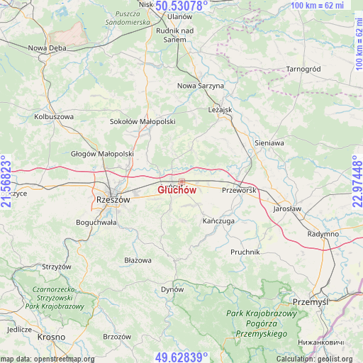
Głuchów GPS coordinates[2]
50° 4' 54.156" North, 22° 16' 16.86" East
| Map corner | latitude | longitude |
|---|---|---|
| Upper-left | 50.53078°, | 21.56823° |
| Center: | 50.08171°, | 22.27135° |
| Lower-right: | 49.62839°, | 22.97448° |
| Map W x H: | 100.3×100.3 km | = 62.3×62.3mi |
| max Lat: | 54.83135° ⇑78.8% North |
| Głuchów: | 50.08171° |
| min Lat: | ⇓21.2% South 49.21328° |
| min Long | Głuchów | max Long |
| 14.20249° | 22.27135° | 24.03723° |
| W 88.4%⇐ | ⇒11.6% E |
Elevation
Elevation of Głuchów is 190 m = 623 ft, and this is 1.4 m = 5 ft below average elevation for this country.
| Max E: |
974 m = 3196 ft | 43.2% |
| Avg. | 191.4 m = 628 ft | |
| Głuchów | 190 m = 623 ft | |
Min E: |
-3 m = -10 ft | 56.8% |
See also: Poland elevation on elevation.city.
Geographical zone
Głuchów is located in North temperate zone (between Tropic of Cancer and the Arctic Circle). Distance of this North polar circle is 1832.6 km =1138.7 mi to North.| Distance of | km | miles | from Głuchów |
|---|---|---|---|
| North Pole | 4438.5 | 2758 | to North |
| Arctic Circle | 1832.6 | 1138.7 | to North |
| Tropic Cancer | 2962.6 | 1840.9 | to South |
| Equator | 5568.6 | 3460.2 | to South |


Nearby cities:
15 places around Głuchów: (largest is in red/bold)
• Albigowa
8.2 km =5.1 mi,  204°
204°
• Białobrzegi
4.1 km =2.5 mi,  55°
55°
• Czarna
7.1 km =4.4 mi,  296°
296°
• Gać
8.7 km =5.4 mi,  134°
134°
• Handzlówka
10.2 km =6.3 mi, 199°
• Kosina
4.3 km =2.7 mi,  104°
104°
• Kraczkowa
8.8 km =5.5 mi,  236°
236°
• Krzemienica
6.8 km =4.2 mi,  251°
251°
• Markowa
7.5 km =4.7 mi,  145°
145°
• Rakszawa
9.1 km =5.7 mi,  345°
345°
• Rogóźno
7.4 km =4.6 mi, 96°
• Sonina
2.4 km =1.5 mi,  190°
190°
• Wysoka
4.2 km =2.6 mi, 191°
• Łańcut
3.3 km =2.1 mi, 244°
• Żołynia
9.3 km =5.8 mi,  16°
16°
Sources, notices
• [Note1] Compared only with cities in Poland existing in our database
• [Src1] Map data: © OpenStreetMap contributors (CC-BY-SA)
• [Src2] Other city data from geonames.org with taken over terms of usage.
• [Src3] Geographical zone / Annual Mean Temperature by Robert A. Rohde @ Wikipedia
