Grabowo geodata
Grabowo (Podlasie) is a populated place; located in Poland in Europe/Warsaw (GMT+2) time zone. With population of 800 people, there are 2851 cities with bigger population in this country. Compared to other cities in Poland, 89.1% of cities are located further ↓South; 86.9% of cities are located further ←West and 55.3% of cities have higher elevation than Grabowo. Note1


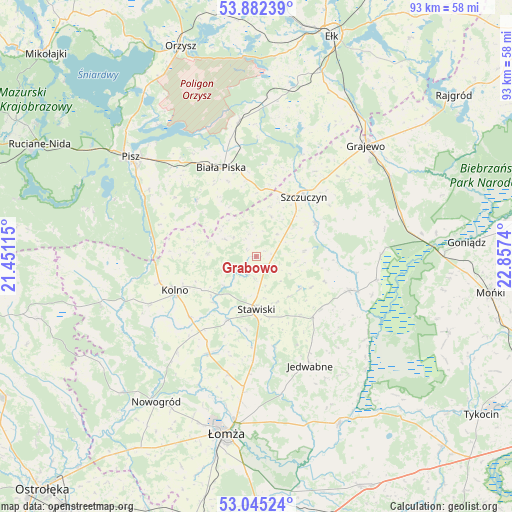
Grabowo GPS coordinates[2]
53° 27' 57.168" North, 22° 9' 15.372" East
| Map corner | latitude | longitude |
|---|---|---|
| Upper-left | 53.88239°, | 21.45115° |
| Center: | 53.46588°, | 22.15427° |
| Lower-right: | 53.04524°, | 22.8574° |
| Map W x H: | 93.1×93.1 km | = 57.8×57.8mi |
| max Lat: | 54.83135° ⇑10.9% North |
| Grabowo: | 53.46588° |
| min Lat: | ⇓89.1% South 49.21328° |
| min Long | Grabowo | max Long |
| 14.20249° | 22.15427° | 24.03723° |
| W 86.9%⇐ | ⇒13.1% E |
Elevation
Elevation of Grabowo is 158 m = 518 ft, and this is 33.4 m = 110 ft below average elevation for this country.
| Max E: |
974 m = 3196 ft | 55.3% |
| Avg. | 191.4 m = 628 ft | |
| Grabowo | 158 m = 518 ft | |
Min E: |
-3 m = -10 ft | 44.7% |
See also: Poland elevation on elevation.city.
Geographical zone
Grabowo is located in North temperate zone (between Tropic of Cancer and the Arctic Circle). Distance of this North polar circle is 1456.3 km =904.9 mi to North.| Distance of | km | miles | from Grabowo |
|---|---|---|---|
| North Pole | 4062.2 | 2524.1 | to North |
| Arctic Circle | 1456.3 | 904.9 | to North |
| Tropic Cancer | 3338.9 | 2074.7 | to South |
| Equator | 5944.8 | 3693.9 | to South |


Nearby cities:
15 places around Grabowo: (largest is in red/bold)
• Biała Piska
17.3 km =10.7 mi,  339°
339°
• Czarnocin
28.5 km =17.7 mi,  190°
190°
• Grajewo
28.3 km =17.6 mi,  44°
44°
• Janowo
20.1 km =12.5 mi,  231°
231°
• Jedwabne
22.4 km =13.9 mi,  153°
153°
• Kolno
16.1 km =10 mi,  247°
247°
• Mały Płock
19.9 km =12.4 mi,  204°
204°
• Nowogród
32.1 km =19.9 mi,  214°
214°
• Pisz
28.9 km =18 mi,  308°
308°
• Piątnica
30.2 km =18.8 mi, 187°
• Prostki
31.7 km =19.7 mi, 35°
• Radziłów
18 km =11.2 mi,  110°
110°
• Stawiski
9.6 km =6 mi,  179°
179°
• Szczuczyn
13.9 km =8.6 mi, 38°
• Wąsosz
12.6 km =7.8 mi,  60°
60°
Sources, notices
• [Note1] Compared only with cities in Poland existing in our database
• [Src1] Map data: © OpenStreetMap contributors (CC-BY-SA)
• [Src2] Other city data from geonames.org with taken over terms of usage.
• [Src3] Geographical zone / Annual Mean Temperature by Robert A. Rohde @ Wikipedia
