Kolno geodata
Kolno (Podlasie) is a populated place; located in Poland in Europe/Warsaw (GMT+2) time zone. With population of 10,659 people, there are 427 cities with bigger population in this country. Compared to other cities in Poland, 88.7% of cities are located further ↓South; 83.9% of cities are located further ←West and 67.4% of cities have higher elevation than Kolno. Note1


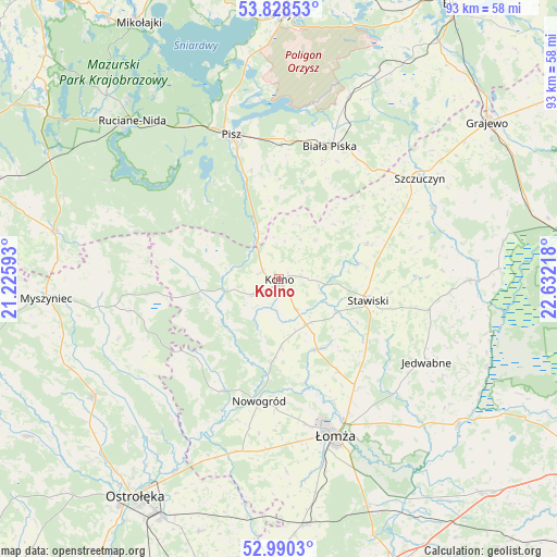
Kolno GPS coordinates[2]
53° 24' 41.328" North, 21° 55' 44.58" East
| Map corner | latitude | longitude |
|---|---|---|
| Upper-left | 53.82853°, | 21.22593° |
| Center: | 53.41148°, | 21.92905° |
| Lower-right: | 52.9903°, | 22.63218° |
| Map W x H: | 93.2×93.2 km | = 57.9×57.9mi |
| max Lat: | 54.83135° ⇑11.3% North |
| Kolno: | 53.41148° |
| min Lat: | ⇓88.7% South 49.21328° |
| min Long | Kolno | max Long |
| 14.20249° | 21.92905° | 24.03723° |
| W 83.9%⇐ | ⇒16.1% E |
Elevation
Elevation of Kolno is 127 m = 417 ft, and this is 64.4 m = 211 ft below average elevation for this country.
| Max E: |
974 m = 3196 ft | 67.4% |
| Avg. | 191.4 m = 628 ft | |
| Kolno | 127 m = 417 ft | |
Min E: |
-3 m = -10 ft | 32.6% |
See also: Poland elevation on elevation.city.
Geographical zone
Kolno is located in North temperate zone (between Tropic of Cancer and the Arctic Circle). Distance of this North polar circle is 1462.4 km =908.7 mi to North.| Distance of | km | miles | from Kolno |
|---|---|---|---|
| North Pole | 4068.3 | 2527.9 | to North |
| Arctic Circle | 1462.4 | 908.7 | to North |
| Tropic Cancer | 3332.9 | 2071 | to South |
| Equator | 5938.8 | 3690.2 | to South |


Nearby cities:
15 places around Kolno: (largest is in red/bold)
• Biała Piska
24 km =14.9 mi,  21°
21°
• Czarnocin
24.1 km =15 mi,  155°
155°
• Grabowo
16.1 km =10 mi,  67°
67°
• Janowo
6.6 km =4.1 mi,  186°
186°
• Jedwabne
28.5 km =17.7 mi,  119°
119°
• Mały Płock
13.7 km =8.5 mi,  151°
151°
• Nowogród
20.8 km =12.9 mi, 188°
• Pisz
25.2 km =15.7 mi,  342°
342°
• Piątnica
26.3 km =16.3 mi, 155°
• Stawiski
15.4 km =9.6 mi,  103°
103°
• Szczuczyn
29 km =18 mi,  54°
54°
• Wąsosz
28.6 km =17.8 mi,  64°
64°
• Zbójna
20.9 km =13 mi,  206°
206°
• Łomża
27.4 km =17 mi, 161°
• Łyse
24.7 km =15.3 mi,  257°
257°
Sources, notices
• [Note1] Compared only with cities in Poland existing in our database
• [Src1] Map data: © OpenStreetMap contributors (CC-BY-SA)
• [Src2] Other city data from geonames.org with taken over terms of usage.
• [Src3] Geographical zone / Annual Mean Temperature by Robert A. Rohde @ Wikipedia
