Krzeszów geodata
Krzeszów (Subcarpathian) is a seat of a third-order administrative division; located in Poland in Europe/Warsaw (GMT+2) time zone. With population of 734 people, there are 2999 cities with bigger population in this country. Compared to other cities in Poland, 69.3% of cities are located further ↑North; 89.5% of cities are located further ←West and 50.6% of cities have lower elevation than Krzeszów. Note1


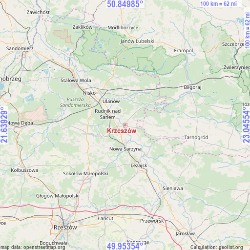
Krzeszów GPS coordinates[2]
50° 24' 13.716" North, 22° 20' 32.676" East
| Map corner | latitude | longitude |
|---|---|---|
| Upper-left | 50.84985°, | 21.63929° |
| Center: | 50.40381°, | 22.34241° |
| Lower-right: | 49.95354°, | 23.04554° |
| Map W x H: | 99.7×99.7 km | = 62×62mi |
| max Lat: | 54.83135° ⇑69.3% North |
| Krzeszów: | 50.40381° |
| min Lat: | ⇓30.7% South 49.21328° |
| min Long | Krzeszów | max Long |
| 14.20249° | 22.34241° | 24.03723° |
| W 89.5%⇐ | ⇒10.5% E |
Elevation
Elevation of Krzeszów is 173 m = 568 ft, and this is 18.4 m = 60 ft below average elevation for this country.
| Max E: |
974 m = 3196 ft | 49.4% |
| Avg. | 191.4 m = 628 ft | |
| Krzeszów | 173 m = 568 ft | |
Min E: |
-3 m = -10 ft | 50.6% |
See also: Poland elevation on elevation.city.
Geographical zone
Krzeszów is located in North temperate zone (between Tropic of Cancer and the Arctic Circle). Distance of this North polar circle is 1796.8 km =1116.5 mi to North.| Distance of | km | miles | from Krzeszów |
|---|---|---|---|
| North Pole | 4402.7 | 2735.7 | to North |
| Arctic Circle | 1796.8 | 1116.5 | to North |
| Tropic Cancer | 2998.5 | 1863.2 | to South |
| Equator | 5604.4 | 3482.4 | to South |


Nearby cities:
15 places around Krzeszów: (largest is in red/bold)
• Bieliny
5 km =3.1 mi,  328°
328°
• Bystre
4.7 km =2.9 mi,  126°
126°
• Harasiuki
12.2 km =7.6 mi,  49°
49°
• Kończyce
13.6 km =8.5 mi,  280°
280°
• Nowa Sarzyna
9.2 km =5.7 mi,  179°
179°
• Przychojec
12.5 km =7.8 mi,  160°
160°
• Przędzel
13.3 km =8.3 mi,  319°
319°
• Rudnik nad Sanem
7.9 km =4.9 mi,  302°
302°
• Tarnogóra
4.3 km =2.7 mi,  203°
203°
• Ulanów
11.1 km =6.9 mi, 329°
• Wola Żarczycka
14.1 km =8.8 mi,  207°
207°
• Wólka Tanewska
12.1 km =7.5 mi, 331°
• Wólka Łętowska
13.1 km =8.1 mi,  226°
226°
• Łukowa
9 km =5.6 mi,  167°
167°
• Łętownia
11.7 km =7.3 mi,  221°
221°
Sources, notices
• [Note1] Compared only with cities in Poland existing in our database
• [Src1] Map data: © OpenStreetMap contributors (CC-BY-SA)
• [Src2] Other city data from geonames.org with taken over terms of usage.
• [Src3] Geographical zone / Annual Mean Temperature by Robert A. Rohde @ Wikipedia
