Pionki geodata
Pionki (Mazovia) is a seat of a third-order administrative division; located in Poland in Europe/Warsaw (GMT+2) time zone. With population of 19,966 people, there are 243 cities with bigger population in this country. Compared to other cities in Poland, 55.9% of cities are located further ↓South; 78.6% of cities are located further ←West and 60.6% of cities have higher elevation than Pionki. Note1


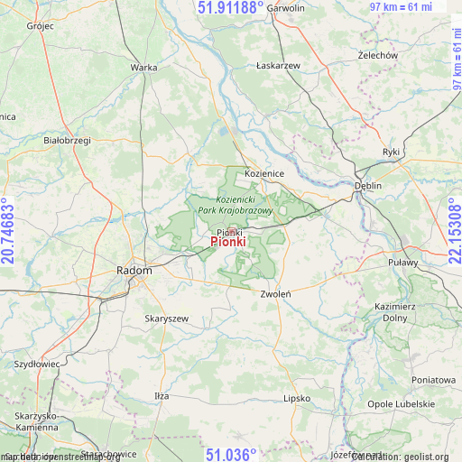
Pionki GPS coordinates[2]
51° 28' 33.744" North, 21° 26' 59.82" East
| Map corner | latitude | longitude |
|---|---|---|
| Upper-left | 51.91188°, | 20.74683° |
| Center: | 51.47604°, | 21.44995° |
| Lower-right: | 51.036°, | 22.15308° |
| Map W x H: | 97.4×97.4 km | = 60.5×60.5mi |
| max Lat: | 54.83135° ⇑44.1% North |
| Pionki: | 51.47604° |
| min Lat: | ⇓55.9% South 49.21328° |
| min Long | Pionki | max Long |
| 14.20249° | 21.44995° | 24.03723° |
| W 78.6%⇐ | ⇒21.4% E |
Elevation
Elevation of Pionki is 145 m = 476 ft, and this is 46.4 m = 152 ft below average elevation for this country.
| Max E: |
974 m = 3196 ft | 60.6% |
| Avg. | 191.4 m = 628 ft | |
| Pionki | 145 m = 476 ft | |
Min E: |
-3 m = -10 ft | 39.4% |
See also: Poland elevation on elevation.city.
Geographical zone
Pionki is located in North temperate zone (between Tropic of Cancer and the Arctic Circle). Distance of this North polar circle is 1677.6 km =1042.4 mi to North.| Distance of | km | miles | from Pionki |
|---|---|---|---|
| North Pole | 4283.5 | 2661.6 | to North |
| Arctic Circle | 1677.6 | 1042.4 | to North |
| Tropic Cancer | 3117.7 | 1937.2 | to South |
| Equator | 5723.6 | 3556.5 | to South |


Nearby cities:
15 places around Pionki: (largest is in red/bold)
• Garbatka-Letnisko
11.2 km =7 mi,  85°
85°
• Gózd
11.9 km =7.4 mi,  204°
204°
• Głowaczów
18.7 km =11.6 mi,  330°
330°
• Janików
13.9 km =8.6 mi,  40°
40°
• Jastrzębia
14.9 km =9.3 mi,  279°
279°
• Jedlnia-Letnisko
9.4 km =5.8 mi,  237°
237°
• Kazanów
22.3 km =13.9 mi,  176°
176°
• Kobylnica
20.8 km =12.9 mi,  24°
24°
• Kozienice
13.7 km =8.5 mi,  29°
29°
• Maków
19.9 km =12.4 mi,  223°
223°
• Paprotnia
22.6 km =14 mi, 40°
• Policzna
12.5 km =7.8 mi,  100°
100°
• Radom
22.5 km =14 mi,  248°
248°
• Tczów
16.7 km =10.4 mi, 180°
• Zwoleń
16.5 km =10.3 mi,  144°
144°
Sources, notices
• [Note1] Compared only with cities in Poland existing in our database
• [Src1] Map data: © OpenStreetMap contributors (CC-BY-SA)
• [Src2] Other city data from geonames.org with taken over terms of usage.
• [Src3] Geographical zone / Annual Mean Temperature by Robert A. Rohde @ Wikipedia
