Sępopol geodata
Sępopol (Warmia-Masuria) is a seat of a third-order administrative division; located in Poland in Europe/Warsaw (GMT+2) time zone. With population of 2,043 people, there are 1451 cities with bigger population in this country. Compared to other cities in Poland, 97.2% of cities are located further ↓South; 72.9% of cities are located further ←West and 96% of cities have higher elevation than Sępopol. Note1


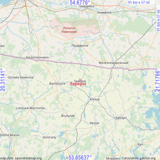
Sępopol GPS coordinates[2]
54° 16' 8.508" North, 21° 0' 52.308" East
| Map corner | latitude | longitude |
|---|---|---|
| Upper-left | 54.6776°, | 20.31141° |
| Center: | 54.26903°, | 21.01453° |
| Lower-right: | 53.85637°, | 21.71766° |
| Map W x H: | 91.3×91.3 km | = 56.7×56.7mi |
| max Lat: | 54.83135° ⇑2.8% North |
| Sępopol: | 54.26903° |
| min Lat: | ⇓97.2% South 49.21328° |
| min Long | Sępopol | max Long |
| 14.20249° | 21.01453° | 24.03723° |
| W 72.9%⇐ | ⇒27.1% E |
Elevation
Elevation of Sępopol is 32 m = 105 ft, and this is 159.4 m = 523 ft below average elevation for this country.
| Max E: |
974 m = 3196 ft | 96% |
| Avg. | 191.4 m = 628 ft | |
| Sępopol | 32 m = 105 ft | |
Min E: |
-3 m = -10 ft | 4% |
See also: Poland elevation on elevation.city.
Geographical zone
Sępopol is located in North temperate zone (between Tropic of Cancer and the Arctic Circle). Distance of this North polar circle is 1367 km =849.4 mi to North.| Distance of | km | miles | from Sępopol |
|---|---|---|---|
| North Pole | 3972.9 | 2468.6 | to North |
| Arctic Circle | 1367 | 849.4 | to North |
| Tropic Cancer | 3428.2 | 2130.2 | to South |
| Equator | 6034.2 | 3749.5 | to South |


Nearby cities:
15 places around Sępopol: (largest is in red/bold)
• Barciany
22.7 km =14.1 mi,  103°
103°
• Bartoszyce
13.5 km =8.4 mi,  262°
262°
• Biskupiec
45.1 km =28 mi,  184°
184°
• Bisztynek
21.6 km =13.4 mi,  199°
199°
• Czerwonka
40 km =24.9 mi,  191°
191°
• Gierłoż
37.6 km =23.4 mi,  123°
123°
• Górowo Iławeckie
34.2 km =21.3 mi,  273°
273°
• Janikowo
36.4 km =22.6 mi, 261°
• Jeziorany
37 km =23 mi,  208°
208°
• Kolno
30.3 km =18.8 mi, 182°
• Korsze
13.7 km =8.5 mi,  143°
143°
• Kętrzyn
31.8 km =19.8 mi,  132°
132°
• Lidzbark Warmiński
32.5 km =20.2 mi,  240°
240°
• Reszel
25.8 km =16 mi,  160°
160°
• Srokowo
33.6 km =20.9 mi, 100°
Sources, notices
• [Note1] Compared only with cities in Poland existing in our database
• [Src1] Map data: © OpenStreetMap contributors (CC-BY-SA)
• [Src2] Other city data from geonames.org with taken over terms of usage.
• [Src3] Geographical zone / Annual Mean Temperature by Robert A. Rohde @ Wikipedia
