Kampinos geodata
Kampinos (Mazovia) is a seat of a third-order administrative division; located in Poland in Europe/Warsaw (GMT+2) time zone. With population of 723 people, there are 3022 cities with bigger population in this country. Compared to other cities in Poland, 71.9% of cities are located further ↓South; 64.6% of cities are located further ←West and 86.8% of cities have higher elevation than Kampinos. Note1


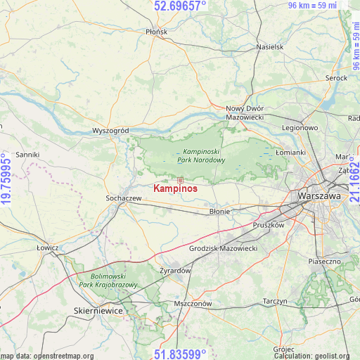
Kampinos GPS coordinates[2]
52° 16' 6.132" North, 20° 27' 47.052" East
| Map corner | latitude | longitude |
|---|---|---|
| Upper-left | 52.69657°, | 19.75995° |
| Center: | 52.26837°, | 20.46307° |
| Lower-right: | 51.83599°, | 21.1662° |
| Map W x H: | 95.7×95.7 km | = 59.5×59.5mi |
| max Lat: | 54.83135° ⇑28.1% North |
| Kampinos: | 52.26837° |
| min Lat: | ⇓71.9% South 49.21328° |
| min Long | Kampinos | max Long |
| 14.20249° | 20.46307° | 24.03723° |
| W 64.6%⇐ | ⇒35.4% E |
Elevation
Elevation of Kampinos is 85 m = 279 ft, and this is 106.4 m = 349 ft below average elevation for this country.
| Max E: |
974 m = 3196 ft | 86.8% |
| Avg. | 191.4 m = 628 ft | |
| Kampinos | 85 m = 279 ft | |
Min E: |
-3 m = -10 ft | 13.2% |
See also: Poland elevation on elevation.city.
Geographical zone
Kampinos is located in North temperate zone (between Tropic of Cancer and the Arctic Circle). Distance of this North polar circle is 1589.5 km =987.7 mi to North.| Distance of | km | miles | from Kampinos |
|---|---|---|---|
| North Pole | 4195.4 | 2606.9 | to North |
| Arctic Circle | 1589.5 | 987.7 | to North |
| Tropic Cancer | 3205.8 | 1992 | to South |
| Equator | 5811.7 | 3611.2 | to South |


Nearby cities:
15 places around Kampinos: (largest is in red/bold)
• Bieniewice
11.7 km =7.3 mi,  144°
144°
• Boża Wola
10 km =6.2 mi,  155°
155°
• Brochów
14.8 km =9.2 mi,  292°
292°
• Błonie
13.1 km =8.1 mi,  126°
126°
• Czerwińsk Nad Wisłą
17.8 km =11.1 mi,  324°
324°
• Czerwonka-Parcel
14.7 km =9.1 mi,  246°
246°
• Guzów
19 km =11.8 mi,  206°
206°
• Józefów
17.9 km =11.1 mi,  117°
117°
• Kozłów Biskupi
20.3 km =12.6 mi, 245°
• Leszno
8.8 km =5.5 mi,  97°
97°
• Młodzieszyn
18.2 km =11.3 mi,  280°
280°
• Paprotnia
7.5 km =4.7 mi,  201°
201°
• Sochaczew
15.9 km =9.9 mi, 254°
• Teresin
8.3 km =5.2 mi, 202°
• Zaborów
14.6 km =9.1 mi,  92°
92°
Sources, notices
• [Note1] Compared only with cities in Poland existing in our database
• [Src1] Map data: © OpenStreetMap contributors (CC-BY-SA)
• [Src2] Other city data from geonames.org with taken over terms of usage.
• [Src3] Geographical zone / Annual Mean Temperature by Robert A. Rohde @ Wikipedia
