Kraczkowa geodata
Kraczkowa (Subcarpathian) is a populated place; located in Poland in Europe/Warsaw (GMT+2) time zone. With population of 3,200 people, there are 991 cities with bigger population in this country. Compared to other cities in Poland, 80.6% of cities are located further ↑North; 87% of cities are located further ←West and 68.7% of cities have lower elevation than Kraczkowa. Note1


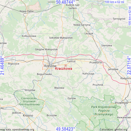
Kraczkowa GPS coordinates[2]
50° 2' 16.656" North, 22° 10' 4.836" East
| Map corner | latitude | longitude |
|---|---|---|
| Upper-left | 50.48744°, | 21.46489° |
| Center: | 50.03796°, | 22.16801° |
| Lower-right: | 49.58423°, | 22.87114° |
| Map W x H: | 100.4×100.4 km | = 62.4×62.4mi |
| max Lat: | 54.83135° ⇑80.6% North |
| Kraczkowa: | 50.03796° |
| min Lat: | ⇓19.4% South 49.21328° |
| min Long | Kraczkowa | max Long |
| 14.20249° | 22.16801° | 24.03723° |
| W 87%⇐ | ⇒13% E |
Elevation
Elevation of Kraczkowa is 225 m = 738 ft, and this is 33.6 m = 110 ft above average elevation for this country.
| Max E: |
974 m = 3196 ft | 31.3% |
| Kraczkowa | 225 m 738 ft | |
| Avg. | 191.4 m = 628 ft | |
Min E: |
-3 m = -10 ft | 68.7% |
See also: Poland elevation on elevation.city.
Geographical zone
Kraczkowa is located in North temperate zone (between Tropic of Cancer and the Arctic Circle). Distance of this North polar circle is 1837.5 km =1141.8 mi to North.| Distance of | km | miles | from Kraczkowa |
|---|---|---|---|
| North Pole | 4443.4 | 2761 | to North |
| Arctic Circle | 1837.5 | 1141.8 | to North |
| Tropic Cancer | 2957.8 | 1837.9 | to South |
| Equator | 5563.7 | 3457.1 | to South |


Nearby cities:
15 places around Kraczkowa: (largest is in red/bold)
• Albigowa
4.8 km =3 mi,  123°
123°
• Chmielnik
7.3 km =4.5 mi,  192°
192°
• Czarna
8 km =5 mi,  6°
6°
• Głuchów
8.8 km =5.5 mi,  56°
56°
• Handzlówka
6.2 km =3.9 mi,  140°
140°
• Husów
10.7 km =6.6 mi,  127°
127°
• Kosina
12.1 km =7.5 mi,  71°
71°
• Krasne
6.2 km =3.9 mi,  289°
289°
• Krzemienica
2.8 km =1.7 mi,  18°
18°
• Markowa
11.8 km =7.3 mi,  96°
96°
• Sonina
7.4 km =4.6 mi, 69°
• Trzebownisko
10.4 km =6.5 mi,  295°
295°
• Wysoka
6.6 km =4.1 mi,  83°
83°
• Wólka Podleśna
9.7 km =6 mi,  335°
335°
• Łańcut
5.5 km =3.4 mi,  51°
51°
Sources, notices
• [Note1] Compared only with cities in Poland existing in our database
• [Src1] Map data: © OpenStreetMap contributors (CC-BY-SA)
• [Src2] Other city data from geonames.org with taken over terms of usage.
• [Src3] Geographical zone / Annual Mean Temperature by Robert A. Rohde @ Wikipedia
