Dorohusk geodata
Dorohusk (Lublin) is a seat of a third-order administrative division; located in Poland in Europe/Warsaw (GMT+2) time zone. With population of 516 people, there are 3500 cities with bigger population in this country. Compared to other cities in Poland, 50.2% of cities are located further ↑North; 99.8% of cities are located further ←West and 50.8% of cities have lower elevation than Dorohusk. Note1


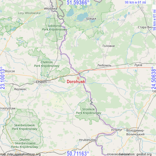
Dorohusk GPS coordinates[2]
51° 9' 17.1" North, 23° 48' 11.7" East
| Map corner | latitude | longitude |
|---|---|---|
| Upper-left | 51.59366°, | 23.10013° |
| Center: | 51.15475°, | 23.80325° |
| Lower-right: | 50.71163°, | 24.50638° |
| Map W x H: | 98.1×98.1 km | = 61×61mi |
| max Lat: | 54.83135° ⇑50.2% North |
| Dorohusk: | 51.15475° |
| min Lat: | ⇓49.8% South 49.21328° |
| min Long | Dorohusk | max Long |
| 14.20249° | 23.80325° | 24.03723° |
| W 99.8%⇐ | ⇒0.2% E |
Elevation
Elevation of Dorohusk is 174 m = 571 ft, and this is 17.4 m = 57 ft below average elevation for this country.
| Max E: |
974 m = 3196 ft | 49.2% |
| Avg. | 191.4 m = 628 ft | |
| Dorohusk | 174 m = 571 ft | |
Min E: |
-3 m = -10 ft | 50.8% |
See also: Poland elevation on elevation.city.
Geographical zone
Dorohusk is located in North temperate zone (between Tropic of Cancer and the Arctic Circle). Distance of this North polar circle is 1713.3 km =1064.6 mi to North.| Distance of | km | miles | from Dorohusk |
|---|---|---|---|
| North Pole | 4319.2 | 2683.8 | to North |
| Arctic Circle | 1713.3 | 1064.6 | to North |
| Tropic Cancer | 3082 | 1915.1 | to South |
| Equator | 5687.9 | 3534.3 | to South |


Nearby cities:
15 places around Dorohusk: (largest is in red/bold)
• Białopole
19.4 km =12.1 mi,  195°
195°
• Chełm
23.2 km =14.4 mi,  266°
266°
• Dorohusk-Osada
1.9 km =1.2 mi,  338°
338°
• Dubienka
13.3 km =8.3 mi,  152°
152°
• Jarosławiec
28.4 km =17.6 mi,  194°
194°
• Kamień
16.6 km =10.3 mi,  246°
246°
• Pokrówka
24.6 km =15.3 mi, 254°
• Ruda-Huta
17.1 km =10.6 mi,  302°
302°
• Sawin
29 km =18 mi, 297°
• Siedliszcze
18.2 km =11.3 mi,  320°
320°
• Uchanie
29.3 km =18.2 mi, 201°
• Wojsławice
31.8 km =19.8 mi,  214°
214°
• Wola Uhruska
22.3 km =13.9 mi,  326°
326°
• Świerże
8.4 km =5.2 mi, 325°
• Żmudź
17.6 km =10.9 mi, 210°
Sources, notices
• [Note1] Compared only with cities in Poland existing in our database
• [Src1] Map data: © OpenStreetMap contributors (CC-BY-SA)
• [Src2] Other city data from geonames.org with taken over terms of usage.
• [Src3] Geographical zone / Annual Mean Temperature by Robert A. Rohde @ Wikipedia
