Wielopole Skrzyńskie geodata
Wielopole Skrzyńskie (Subcarpathian) is a seat of a third-order administrative division; located in Poland in Europe/Warsaw (GMT+2) time zone. With population of 3,982 people, there are 819 cities with bigger population in this country. Compared to other cities in Poland, 85.7% of cities are located further ↑North; 80.4% of cities are located further ←West and 77.6% of cities have lower elevation than Wielopole Skrzyńskie. Note1
Administrative division(s):
- Level 1: Subcarpathian
- Level 2: Powiat ropczycko-sędziszowski
- Level 3: Wielopole Skrzyńskie


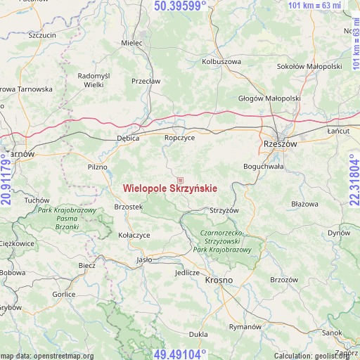
Wielopole Skrzyńskie GPS coordinates[2]
49° 56' 44.304" North, 21° 36' 53.676" East
| Map corner | latitude | longitude |
|---|---|---|
| Upper-left | 50.39599°, | 20.91179° |
| Center: | 49.94564°, | 21.61491° |
| Lower-right: | 49.49104°, | 22.31804° |
| Map W x H: | 100.6×100.6 km | = 62.5×62.5mi |
| max Lat: | 54.83135° ⇑85.7% North |
| Wielopole Skrzyńskie: | 49.94564° |
| min Lat: | ⇓14.3% South 49.21328° |
| min Long | Wielopole Skrzy | max Long |
| 14.20249° | 21.61491° | 24.03723° |
| W 80.4%⇐ | ⇒19.6% E |
Elevation
Elevation of Wielopole Skrzyńskie is 256 m = 840 ft, and this is 64.6 m = 212 ft above average elevation for this country.
| Max E: |
974 m = 3196 ft | 22.4% |
| Wielopole Skrzyńskie | 256 m 840 ft | |
| Avg. | 191.4 m = 628 ft | |
Min E: |
-3 m = -10 ft | 77.6% |
See also: Poland elevation on elevation.city.
Geographical zone
Wielopole Skrzyńskie is located in North temperate zone (between Tropic of Cancer and the Arctic Circle). Distance of this North polar circle is 1847.7 km =1148.1 mi to North.| Distance of | km | miles | from Wielopole Skrzyńskie |
|---|---|---|---|
| North Pole | 4453.6 | 2767.3 | to North |
| Arctic Circle | 1847.7 | 1148.1 | to North |
| Tropic Cancer | 2947.5 | 1831.5 | to South |
| Equator | 5553.4 | 3450.7 | to South |


Nearby cities:
15 places around Wielopole Skrzyńskie: (largest is in red/bold)
• Brzostek
16.3 km =10.1 mi,  243°
243°
• Bystrzyca
8.9 km =5.5 mi,  66°
66°
• Czudec
16.2 km =10.1 mi,  90°
90°
• Frysztak
11.6 km =7.2 mi,  181°
181°
• Iwierzyce
13.6 km =8.5 mi,  46°
46°
• Niedźwiada
8.3 km =5.2 mi,  306°
306°
• Ostrów
17 km =10.6 mi,  354°
354°
• Ropczyce
11.9 km =7.4 mi,  357°
357°
• Strzyżów
15.3 km =9.5 mi,  122°
122°
• Sędziszów Małopolski
15.2 km =9.4 mi,  23°
23°
• Wiśniowa
9 km =5.6 mi,  161°
161°
• Wiśniowa
11.5 km =7.1 mi,  59°
59°
• Wysoka Strzyżowska
15.7 km =9.8 mi,  144°
144°
• Zagórzyce
9 km =5.6 mi,  28°
28°
• Łęki
15.4 km =9.6 mi,  167°
167°
Sources, notices
• [Note1] Compared only with cities in Poland existing in our database
• [Src1] Map data: © OpenStreetMap contributors (CC-BY-SA)
• [Src2] Other city data from geonames.org with taken over terms of usage.
• [Src3] Geographical zone / Annual Mean Temperature by Robert A. Rohde @ Wikipedia
