Kołbiel geodata
Kołbiel (Mazovia) is a seat of a third-order administrative division; located in Poland in Europe/Warsaw (GMT+2) time zone. With population of 3,000 people, there are 1040 cities with bigger population in this country. Compared to other cities in Poland, 66.8% of cities are located further ↓South; 79% of cities are located further ←West and 73.1% of cities have higher elevation than Kołbiel. Note1


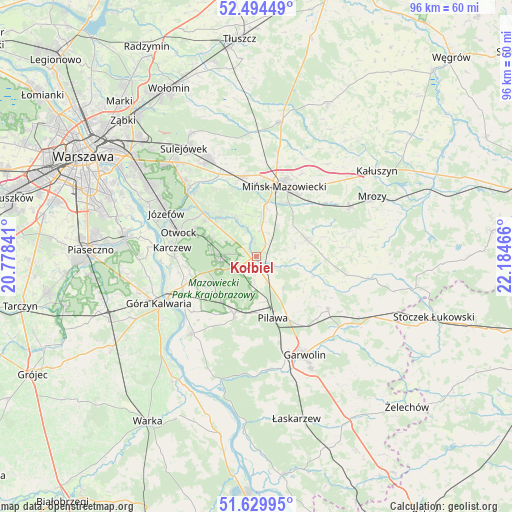
Kołbiel GPS coordinates[2]
52° 3' 51.516" North, 21° 28' 53.508" East
| Map corner | latitude | longitude |
|---|---|---|
| Upper-left | 52.49449°, | 20.77841° |
| Center: | 52.06431°, | 21.48153° |
| Lower-right: | 51.62995°, | 22.18466° |
| Map W x H: | 96.1×96.1 km | = 59.7×59.7mi |
| max Lat: | 54.83135° ⇑33.2% North |
| Kołbiel: | 52.06431° |
| min Lat: | ⇓66.8% South 49.21328° |
| min Long | Kołbiel | max Long |
| 14.20249° | 21.48153° | 24.03723° |
| W 79%⇐ | ⇒21% E |
Elevation
Elevation of Kołbiel is 115 m = 377 ft, and this is 76.4 m = 251 ft below average elevation for this country.
| Max E: |
974 m = 3196 ft | 73.1% |
| Avg. | 191.4 m = 628 ft | |
| Kołbiel | 115 m = 377 ft | |
Min E: |
-3 m = -10 ft | 26.9% |
See also: Poland elevation on elevation.city.
Geographical zone
Kołbiel is located in North temperate zone (between Tropic of Cancer and the Arctic Circle). Distance of this North polar circle is 1612.2 km =1001.8 mi to North.| Distance of | km | miles | from Kołbiel |
|---|---|---|---|
| North Pole | 4218.1 | 2621 | to North |
| Arctic Circle | 1612.2 | 1001.8 | to North |
| Tropic Cancer | 3183.1 | 1977.9 | to South |
| Equator | 5789 | 3597.1 | to South |


Nearby cities:
15 places around Kołbiel: (largest is in red/bold)
• Celestynów
6.2 km =3.9 mi,  266°
266°
• Dębe Wielkie
15.3 km =9.5 mi,  350°
350°
• Józefów
18.6 km =11.6 mi,  295°
295°
• Karczew
15.9 km =9.9 mi, 274°
• Miętne
17.1 km =10.6 mi,  158°
158°
• Mińsk Mazowiecki
14.2 km =8.8 mi,  25°
25°
• Osieck
11.7 km =7.3 mi,  201°
201°
• Otwock
15.7 km =9.8 mi,  287°
287°
• Parysów
16.8 km =10.4 mi,  125°
125°
• Pilawa
12.1 km =7.5 mi, 163°
• Pogorzel
9.1 km =5.7 mi,  52°
52°
• Siennica
9.9 km =6.2 mi,  72°
72°
• Trąbki
15.2 km =9.4 mi,  148°
148°
• Wielgolas
17.5 km =10.9 mi,  101°
101°
• Wiązowna
17.5 km =10.9 mi,  312°
312°
Sources, notices
• [Note1] Compared only with cities in Poland existing in our database
• [Src1] Map data: © OpenStreetMap contributors (CC-BY-SA)
• [Src2] Other city data from geonames.org with taken over terms of usage.
• [Src3] Geographical zone / Annual Mean Temperature by Robert A. Rohde @ Wikipedia
