Mińsk Mazowiecki geodata
Mińsk Mazowiecki (Mazovia) is a seat of a second-order administrative division; located in Poland in Europe/Warsaw (GMT+2) time zone. With population of 37,027 people, there are 141 cities with bigger population in this country. Compared to other cities in Poland, 69.5% of cities are located further ↓South; 79.8% of cities are located further ←West and 58.4% of cities have higher elevation than Mińsk Mazowiecki. Note1


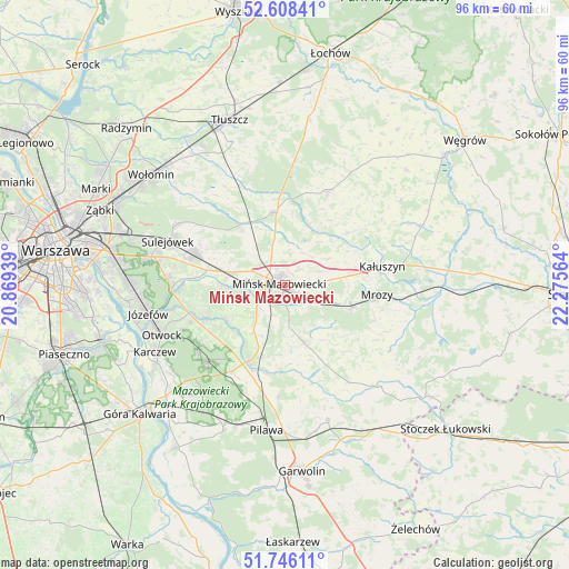
Mińsk Mazowiecki GPS coordinates[2]
52° 10' 45.66" North, 21° 34' 21.036" East
| Map corner | latitude | longitude |
|---|---|---|
| Upper-left | 52.60841°, | 20.86939° |
| Center: | 52.17935°, | 21.57251° |
| Lower-right: | 51.74611°, | 22.27564° |
| Map W x H: | 95.9×95.9 km | = 59.6×59.6mi |
| max Lat: | 54.83135° ⇑30.5% North |
| Mińsk Mazowiecki: | 52.17935° |
| min Lat: | ⇓69.5% South 49.21328° |
| min Long | Mińsk Mazowiec | max Long |
| 14.20249° | 21.57251° | 24.03723° |
| W 79.8%⇐ | ⇒20.2% E |
Elevation
Elevation of Mińsk Mazowiecki is 150 m = 492 ft, and this is 41.4 m = 136 ft below average elevation for this country.
| Max E: |
974 m = 3196 ft | 58.4% |
| Avg. | 191.4 m = 628 ft | |
| Mińsk Mazowiecki | 150 m = 492 ft | |
Min E: |
-3 m = -10 ft | 41.6% |
See also: Poland elevation on elevation.city.
Geographical zone
Mińsk Mazowiecki is located in North temperate zone (between Tropic of Cancer and the Arctic Circle). Distance of this North polar circle is 1599.4 km =993.8 mi to North.| Distance of | km | miles | from Mińsk Mazowiecki |
|---|---|---|---|
| North Pole | 4205.3 | 2613.1 | to North |
| Arctic Circle | 1599.4 | 993.8 | to North |
| Tropic Cancer | 3195.9 | 1985.8 | to South |
| Equator | 5801.8 | 3605.1 | to South |


Nearby cities:
15 places around Mińsk Mazowiecki: (largest is in red/bold)
• Cegłów
11.8 km =7.3 mi,  107°
107°
• Celestynów
18.1 km =11.2 mi,  223°
223°
• Dobre
17.3 km =10.7 mi,  24°
24°
• Dębe Wielkie
9.1 km =5.7 mi,  284°
284°
• Halinów
15.8 km =9.8 mi,  290°
290°
• Jakubów
8.6 km =5.3 mi,  58°
58°
• Kałuszyn
16.4 km =10.2 mi,  79°
79°
• Kołbiel
14.2 km =8.8 mi,  205°
205°
• Mrozy
15.8 km =9.8 mi,  95°
95°
• Pogorzel
7.3 km =4.5 mi,  172°
172°
• Poświętne
19.6 km =12.2 mi,  328°
328°
• Siennica
10.3 km =6.4 mi,  161°
161°
• Stanisławów
12.3 km =7.6 mi,  352°
352°
• Wiązowna
19.2 km =11.9 mi,  267°
267°
• Wiśniew
13.6 km =8.5 mi,  49°
49°
In other languages:
- In Russian: Миньск-Мазовецки, Миньск-Мазовецкий, Ново-Минск
- In Chinese: 馬佐夫舍地區明斯克
Sources, notices
• [Note1] Compared only with cities in Poland existing in our database
• [Src1] Map data: © OpenStreetMap contributors (CC-BY-SA)
• [Src2] Other city data from geonames.org with taken over terms of usage.
• [Src3] Geographical zone / Annual Mean Temperature by Robert A. Rohde @ Wikipedia
