Imielno geodata
Imielno (Świętokrzyskie) is a seat of a third-order administrative division; located in Poland in Europe/Warsaw (GMT+2) time zone. With population of 300 people, there are 3621 cities with bigger population in this country. Compared to other cities in Poland, 65.5% of cities are located further ↑North; 64.3% of cities are located further ←West and 64.5% of cities have lower elevation than Imielno. Note1


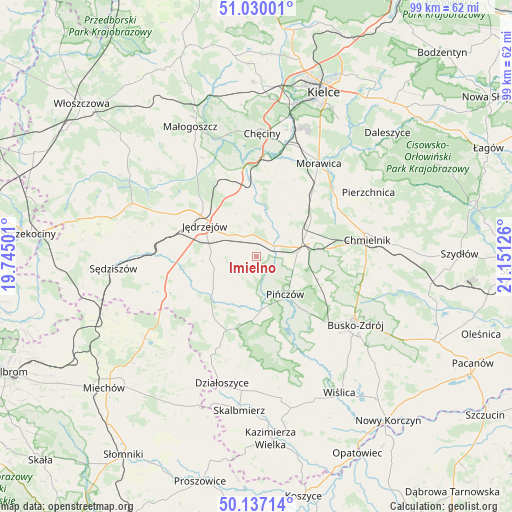
Imielno GPS coordinates[2]
50° 35' 8.484" North, 20° 26' 53.268" East
| Map corner | latitude | longitude |
|---|---|---|
| Upper-left | 51.03001°, | 19.74501° |
| Center: | 50.58569°, | 20.44813° |
| Lower-right: | 50.13714°, | 21.15126° |
| Map W x H: | 99.3×99.3 km | = 61.7×61.7mi |
| max Lat: | 54.83135° ⇑65.5% North |
| Imielno: | 50.58569° |
| min Lat: | ⇓34.5% South 49.21328° |
| min Long | Imielno | max Long |
| 14.20249° | 20.44813° | 24.03723° |
| W 64.3%⇐ | ⇒35.7% E |
Elevation
Elevation of Imielno is 213 m = 699 ft, and this is 21.6 m = 71 ft above average elevation for this country.
| Max E: |
974 m = 3196 ft | 35.5% |
| Imielno | 213 m 699 ft | |
| Avg. | 191.4 m = 628 ft | |
Min E: |
-3 m = -10 ft | 64.5% |
See also: Poland elevation on elevation.city.
Geographical zone
Imielno is located in North temperate zone (between Tropic of Cancer and the Arctic Circle). Distance of this North polar circle is 1776.6 km =1103.9 mi to North.| Distance of | km | miles | from Imielno |
|---|---|---|---|
| North Pole | 4382.5 | 2723.2 | to North |
| Arctic Circle | 1776.6 | 1103.9 | to North |
| Tropic Cancer | 3018.7 | 1875.7 | to South |
| Equator | 5624.6 | 3495 | to South |


Nearby cities:
15 places around Imielno: (largest is in red/bold)
• Brzeziny
22.6 km =14 mi,  22°
22°
• Busko-Zdrój
23 km =14.3 mi,  123°
123°
• Chmielnik
21.7 km =13.5 mi,  81°
81°
• Chęciny
23.9 km =14.9 mi,  2°
2°
• Jędrzejów
11.8 km =7.3 mi,  300°
300°
• Kije
9 km =5.6 mi,  74°
74°
• Korytnica
9.3 km =5.8 mi,  30°
30°
• Michałów
10.1 km =6.3 mi,  174°
174°
• Morawica
21.5 km =13.4 mi, 33°
• Pińczów
9.1 km =5.7 mi,  142°
142°
• Potok Wielki
15.7 km =9.8 mi,  276°
276°
• Siedlce
17.8 km =11.1 mi,  10°
10°
• Sobków
12.7 km =7.9 mi, 0°
• Wodzisław
19.5 km =12.1 mi,  248°
248°
• Łukowa
16.8 km =10.4 mi, 22°
Sources, notices
• [Note1] Compared only with cities in Poland existing in our database
• [Src1] Map data: © OpenStreetMap contributors (CC-BY-SA)
• [Src2] Other city data from geonames.org with taken over terms of usage.
• [Src3] Geographical zone / Annual Mean Temperature by Robert A. Rohde @ Wikipedia
