Baboszewo geodata
Baboszewo (Mazovia) is a seat of a third-order administrative division; located in Poland in Europe/Warsaw (GMT+2) time zone. With population of 1,800 people, there are 1605 cities with bigger population in this country. Compared to other cities in Poland, 79% of cities are located further ↓South; 61.9% of cities are located further ←West and 78.4% of cities have higher elevation than Baboszewo. Note1


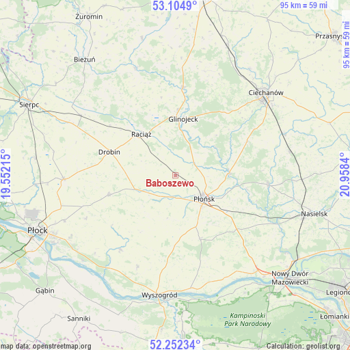
Baboszewo GPS coordinates[2]
52° 40' 50.52" North, 20° 15' 18.972" East
| Map corner | latitude | longitude |
|---|---|---|
| Upper-left | 53.1049°, | 19.55215° |
| Center: | 52.6807°, | 20.25527° |
| Lower-right: | 52.25234°, | 20.9584° |
| Map W x H: | 94.8×94.8 km | = 58.9×58.9mi |
| max Lat: | 54.83135° ⇑21% North |
| Baboszewo: | 52.6807° |
| min Lat: | ⇓79% South 49.21328° |
| min Long | Baboszewo | max Long |
| 14.20249° | 20.25527° | 24.03723° |
| W 61.9%⇐ | ⇒38.1% E |
Elevation
Elevation of Baboszewo is 103 m = 338 ft, and this is 88.4 m = 290 ft below average elevation for this country.
| Max E: |
974 m = 3196 ft | 78.4% |
| Avg. | 191.4 m = 628 ft | |
| Baboszewo | 103 m = 338 ft | |
Min E: |
-3 m = -10 ft | 21.6% |
See also: Poland elevation on elevation.city.
Geographical zone
Baboszewo is located in North temperate zone (between Tropic of Cancer and the Arctic Circle). Distance of this North polar circle is 1543.6 km =959.1 mi to North.| Distance of | km | miles | from Baboszewo |
|---|---|---|---|
| North Pole | 4149.5 | 2578.4 | to North |
| Arctic Circle | 1543.6 | 959.1 | to North |
| Tropic Cancer | 3251.6 | 2020.4 | to South |
| Equator | 5857.5 | 3639.7 | to South |


Nearby cities:
15 places around Baboszewo: (largest is in red/bold)
• Bodzanów
25.2 km =15.7 mi,  217°
217°
• Bulkowo
18.1 km =11.2 mi,  210°
210°
• Drobin
19 km =11.8 mi,  289°
289°
• Dzierzążnia
6 km =3.7 mi,  194°
194°
• Glinojeck
15.7 km =9.8 mi,  9°
9°
• Joniec
23.7 km =14.7 mi,  111°
111°
• Naruszewo
18.3 km =11.4 mi,  159°
159°
• Nowe Miasto
25.3 km =15.7 mi,  96°
96°
• Ojrzeń
21.6 km =13.4 mi,  64°
64°
• Płońsk
10.3 km =6.4 mi,  128°
128°
• Raciąż
14.5 km =9 mi,  320°
320°
• Sochocin
14.7 km =9.1 mi,  87°
87°
• Staroźreby
19 km =11.8 mi,  253°
253°
• Strzegowo
23.8 km =14.8 mi,  4°
4°
• Załuski
26.4 km =16.4 mi,  135°
135°
Sources, notices
• [Note1] Compared only with cities in Poland existing in our database
• [Src1] Map data: © OpenStreetMap contributors (CC-BY-SA)
• [Src2] Other city data from geonames.org with taken over terms of usage.
• [Src3] Geographical zone / Annual Mean Temperature by Robert A. Rohde @ Wikipedia
