Bałtów geodata
Bałtów (Lublin) is a populated place; located in Poland in Europe/Warsaw (GMT+2) time zone. With population of 522 people, there are 3477 cities with bigger population in this country. Compared to other cities in Poland, 56.1% of cities are located further ↓South; 85.1% of cities are located further ←West and 61.1% of cities have higher elevation than Bałtów. Note1


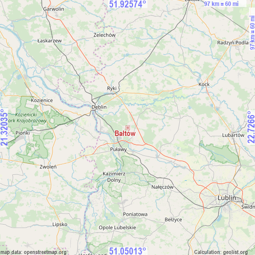
Bałtów GPS coordinates[2]
51° 29' 24.144" North, 22° 1' 24.492" East
| Map corner | latitude | longitude |
|---|---|---|
| Upper-left | 51.92574°, | 21.32035° |
| Center: | 51.49004°, | 22.02347° |
| Lower-right: | 51.05013°, | 22.7266° |
| Map W x H: | 97.4×97.4 km | = 60.5×60.5mi |
| max Lat: | 54.83135° ⇑43.9% North |
| Bałtów: | 51.49004° |
| min Lat: | ⇓56.1% South 49.21328° |
| min Long | Bałtów | max Long |
| 14.20249° | 22.02347° | 24.03723° |
| W 85.1%⇐ | ⇒14.9% E |
Elevation
Elevation of Bałtów is 144 m = 472 ft, and this is 47.4 m = 156 ft below average elevation for this country.
| Max E: |
974 m = 3196 ft | 61.1% |
| Avg. | 191.4 m = 628 ft | |
| Bałtów | 144 m = 472 ft | |
Min E: |
-3 m = -10 ft | 38.9% |
See also: Poland elevation on elevation.city.
Geographical zone
Bałtów is located in North temperate zone (between Tropic of Cancer and the Arctic Circle). Distance of this North polar circle is 1676 km =1041.4 mi to North.| Distance of | km | miles | from Bałtów |
|---|---|---|---|
| North Pole | 4281.9 | 2660.6 | to North |
| Arctic Circle | 1676 | 1041.4 | to North |
| Tropic Cancer | 3119.2 | 1938.2 | to South |
| Equator | 5725.2 | 3557.5 | to South |


Nearby cities:
15 places around Bałtów: (largest is in red/bold)
• Baranów
10.9 km =6.8 mi,  45°
45°
• Bobrowniki
9 km =5.6 mi,  316°
316°
• Brzozowa Gać
14.9 km =9.3 mi,  133°
133°
• Dęblin
14.3 km =8.9 mi,  302°
302°
• Gniewoszów
14.7 km =9.1 mi,  263°
263°
• Kazimierz Dolny
19.6 km =12.2 mi,  194°
194°
• Końskowola
9.2 km =5.7 mi,  167°
167°
• Kurów
15.9 km =9.9 mi, 134°
• Moszczanka
12.9 km =8 mi,  341°
341°
• Nowodwór
17.4 km =10.8 mi,  18°
18°
• Puławy
9 km =5.6 mi,  204°
204°
• Ryki
16.3 km =10.1 mi, 337°
• Stężyca
20.2 km =12.6 mi, 300°
• Ułęż
12.7 km =7.9 mi,  27°
27°
• Żyrzyn
4.8 km =3 mi,  77°
77°
Sources, notices
• [Note1] Compared only with cities in Poland existing in our database
• [Src1] Map data: © OpenStreetMap contributors (CC-BY-SA)
• [Src2] Other city data from geonames.org with taken over terms of usage.
• [Src3] Geographical zone / Annual Mean Temperature by Robert A. Rohde @ Wikipedia
