Harasiuki geodata
Harasiuki (Subcarpathian) is a seat of a third-order administrative division; located in Poland in Europe/Warsaw (GMT+2) time zone. With population of 862 people, there are 2744 cities with bigger population in this country. Compared to other cities in Poland, 67.7% of cities are located further ↑North; 91.3% of cities are located further ←West and 50.2% of cities have higher elevation than Harasiuki. Note1


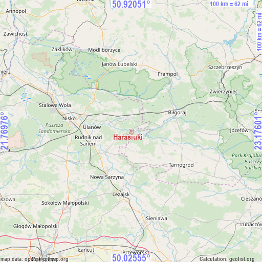
Harasiuki GPS coordinates[2]
50° 28' 30.54" North, 22° 28' 22.368" East
| Map corner | latitude | longitude |
|---|---|---|
| Upper-left | 50.92051°, | 21.76976° |
| Center: | 50.47515°, | 22.47288° |
| Lower-right: | 50.02555°, | 23.17601° |
| Map W x H: | 99.5×99.5 km | = 61.8×61.8mi |
| max Lat: | 54.83135° ⇑67.7% North |
| Harasiuki: | 50.47515° |
| min Lat: | ⇓32.3% South 49.21328° |
| min Long | Harasiuki | max Long |
| 14.20249° | 22.47288° | 24.03723° |
| W 91.3%⇐ | ⇒8.7% E |
Elevation
Elevation of Harasiuki is 171 m = 561 ft, and this is 20.4 m = 67 ft below average elevation for this country.
| Max E: |
974 m = 3196 ft | 50.2% |
| Avg. | 191.4 m = 628 ft | |
| Harasiuki | 171 m = 561 ft | |
Min E: |
-3 m = -10 ft | 49.8% |
See also: Poland elevation on elevation.city.
Geographical zone
Harasiuki is located in North temperate zone (between Tropic of Cancer and the Arctic Circle). Distance of this North polar circle is 1788.9 km =1111.6 mi to North.| Distance of | km | miles | from Harasiuki |
|---|---|---|---|
| North Pole | 4394.8 | 2730.8 | to North |
| Arctic Circle | 1788.9 | 1111.6 | to North |
| Tropic Cancer | 3006.4 | 1868.1 | to South |
| Equator | 5612.3 | 3487.3 | to South |


Nearby cities:
15 places around Harasiuki: (largest is in red/bold)
• Bieliny
12.4 km =7.7 mi,  252°
252°
• Biszcza
15 km =9.3 mi,  123°
123°
• Biłgoraj
19.1 km =11.9 mi,  67°
67°
• Bystre
12 km =7.5 mi,  206°
206°
• Jarocin
14.6 km =9.1 mi,  312°
312°
• Krzeszów
12.2 km =7.6 mi,  229°
229°
• Księżpol
19.5 km =12.1 mi,  107°
107°
• Nowa Sarzyna
19.4 km =12.1 mi, 207°
• Potok Górny
11.9 km =7.4 mi,  147°
147°
• Przędzel
18.1 km =11.2 mi,  276°
276°
• Rudnik nad Sanem
16.3 km =10.1 mi,  256°
256°
• Tarnogóra
16.1 km =10 mi,  222°
222°
• Ulanów
14.9 km =9.3 mi, 276°
• Wólka Tanewska
15.2 km =9.4 mi, 280°
• Łukowa
18.2 km =11.3 mi,  203°
203°
Sources, notices
• [Note1] Compared only with cities in Poland existing in our database
• [Src1] Map data: © OpenStreetMap contributors (CC-BY-SA)
• [Src2] Other city data from geonames.org with taken over terms of usage.
• [Src3] Geographical zone / Annual Mean Temperature by Robert A. Rohde @ Wikipedia
