Czyże geodata
Czyże (Podlasie) is a populated place; located in Poland in Europe/Warsaw (GMT+2) time zone. With population of 590 people, there are 3306 cities with bigger population in this country. Compared to other cities in Poland, 80.5% of cities are located further ↓South; 98.5% of cities are located further ←West and 55.3% of cities have higher elevation than Czyże. Note1


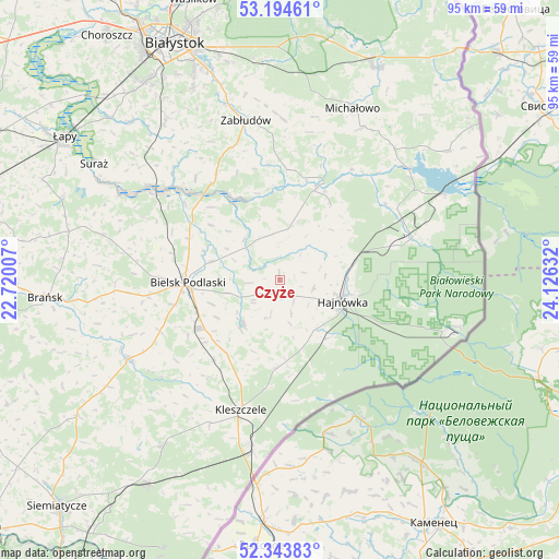
Czyże GPS coordinates[2]
52° 46' 16.68" North, 23° 25' 23.484" East
| Map corner | latitude | longitude |
|---|---|---|
| Upper-left | 53.19461°, | 22.72007° |
| Center: | 52.7713°, | 23.42319° |
| Lower-right: | 52.34383°, | 24.12632° |
| Map W x H: | 94.6×94.6 km | = 58.8×58.8mi |
| max Lat: | 54.83135° ⇑19.5% North |
| Czyże: | 52.7713° |
| min Lat: | ⇓80.5% South 49.21328° |
| min Long | Czyże | max Long |
| 14.20249° | 23.42319° | 24.03723° |
| W 98.5%⇐ | ⇒1.5% E |
Elevation
Elevation of Czyże is 158 m = 518 ft, and this is 33.4 m = 110 ft below average elevation for this country.
| Max E: |
974 m = 3196 ft | 55.3% |
| Avg. | 191.4 m = 628 ft | |
| Czyże | 158 m = 518 ft | |
Min E: |
-3 m = -10 ft | 44.7% |
See also: Poland elevation on elevation.city.
Geographical zone
Czyże is located in North temperate zone (between Tropic of Cancer and the Arctic Circle). Distance of this North polar circle is 1533.6 km =952.9 mi to North.| Distance of | km | miles | from Czyże |
|---|---|---|---|
| North Pole | 4139.4 | 2572.1 | to North |
| Arctic Circle | 1533.6 | 952.9 | to North |
| Tropic Cancer | 3261.7 | 2026.7 | to South |
| Equator | 5867.6 | 3646 | to South |


Nearby cities:
15 places around Czyże: (largest is in red/bold)
• Białowieża
30.9 km =19.2 mi,  104°
104°
• Bielsk Podlaski
15.9 km =9.9 mi,  267°
267°
• Boćki
28.8 km =17.9 mi,  242°
242°
• Czeremcha
28.7 km =17.8 mi,  189°
189°
• Hajnówka
11.1 km =6.9 mi,  106°
106°
• Kleszczele
23 km =14.3 mi,  196°
196°
• Michałowo
31.9 km =19.8 mi,  23°
23°
• Milejczyce
34.2 km =21.3 mi,  215°
215°
• Narew
17.2 km =10.7 mi, 22°
• Narewka
23.8 km =14.8 mi,  73°
73°
• Orla
9.5 km =5.9 mi, 219°
• Suraż
37 km =23 mi,  302°
302°
• Turośń Kościelna
36.6 km =22.7 mi,  317°
317°
• Wyszki
30.7 km =19.1 mi,  284°
284°
• Zabłudów
27.6 km =17.1 mi,  348°
348°
Sources, notices
• [Note1] Compared only with cities in Poland existing in our database
• [Src1] Map data: © OpenStreetMap contributors (CC-BY-SA)
• [Src2] Other city data from geonames.org with taken over terms of usage.
• [Src3] Geographical zone / Annual Mean Temperature by Robert A. Rohde @ Wikipedia
