Hajnówka geodata
Hajnówka (Podlasie) is a seat of a third-order administrative division; located in Poland in Europe/Warsaw (GMT+2) time zone. With population of 22,157 people, there are 220 cities with bigger population in this country. Compared to other cities in Poland, 80% of cities are located further ↓South; 99% of cities are located further ←West and 53.7% of cities have higher elevation than Hajnówka. Note1


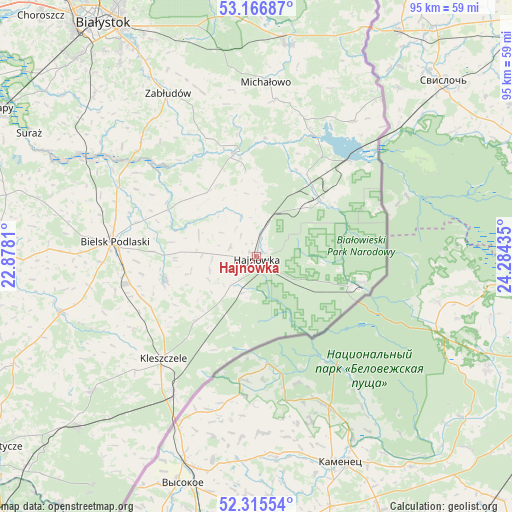
Hajnówka GPS coordinates[2]
52° 44' 35.808" North, 23° 34' 52.392" East
| Map corner | latitude | longitude |
|---|---|---|
| Upper-left | 53.16687°, | 22.8781° |
| Center: | 52.74328°, | 23.58122° |
| Lower-right: | 52.31554°, | 24.28435° |
| Map W x H: | 94.7×94.7 km | = 58.8×58.8mi |
| max Lat: | 54.83135° ⇑20% North |
| Hajnówka: | 52.74328° |
| min Lat: | ⇓80% South 49.21328° |
| min Long | Hajnówka | max Long |
| 14.20249° | 23.58122° | 24.03723° |
| W 99%⇐ | ⇒1% E |
Elevation
Elevation of Hajnówka is 162 m = 531 ft, and this is 29.4 m = 96 ft below average elevation for this country.
| Max E: |
974 m = 3196 ft | 53.7% |
| Avg. | 191.4 m = 628 ft | |
| Hajnówka | 162 m = 531 ft | |
Min E: |
-3 m = -10 ft | 46.3% |
See also: Poland elevation on elevation.city.
Geographical zone
Hajnówka is located in North temperate zone (between Tropic of Cancer and the Arctic Circle). Distance of this North polar circle is 1536.7 km =954.9 mi to North.| Distance of | km | miles | from Hajnówka |
|---|---|---|---|
| North Pole | 4142.6 | 2574.1 | to North |
| Arctic Circle | 1536.7 | 954.9 | to North |
| Tropic Cancer | 3258.6 | 2024.8 | to South |
| Equator | 5864.5 | 3644 | to South |


Nearby cities:
15 places around Hajnówka: (largest is in red/bold)
• Białowieża
19.8 km =12.3 mi,  104°
104°
• Bielsk Podlaski
26.7 km =16.6 mi,  275°
275°
• Boćki
37.6 km =23.4 mi,  254°
254°
• Czeremcha
29.6 km =18.4 mi,  211°
211°
• Czyże
11.1 km =6.9 mi,  286°
286°
• Grudki
39.5 km =24.5 mi,  8°
8°
• Kleszczele
25.6 km =15.9 mi,  222°
222°
• Michałowo
32.5 km =20.2 mi,  3°
3°
• Milejczyce
39.2 km =24.4 mi,  230°
230°
• Narew
19.4 km =12.1 mi,  347°
347°
• Narewka
15.8 km =9.8 mi,  50°
50°
• Nurzec-Stacja
45.8 km =28.5 mi, 226°
• Orla
17.3 km =10.7 mi,  255°
255°
• Wyszki
41.8 km =26 mi, 285°
• Zabłudów
34.3 km =21.3 mi,  331°
331°
Sources, notices
• [Note1] Compared only with cities in Poland existing in our database
• [Src1] Map data: © OpenStreetMap contributors (CC-BY-SA)
• [Src2] Other city data from geonames.org with taken over terms of usage.
• [Src3] Geographical zone / Annual Mean Temperature by Robert A. Rohde @ Wikipedia
