Shilka geodata
Shilka (Transbaikal Territory) is a populated place; located in Russia in Asia/Chita (GMT+9) time zone. With population of 14,132 people, there are 1135 cities with bigger population in this country. Compared to other cities in Russia, 70.1% of cities are located further ↑North; 92.4% of cities are located further ←West and 91.6% of cities have lower elevation than Shilka. Note1


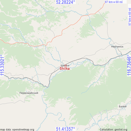
Shilka GPS coordinates[2]
51° 51' 0" North, 116° 1' 59.988" East
| Map corner | latitude | longitude |
|---|---|---|
| Upper-left | 52.28224°, | 115.33021° |
| Center: | 51.85°, | 116.03333° |
| Lower-right: | 51.41357°, | 116.73646° |
| Map W x H: | 96.6×96.6 km | = 60×60mi |
| max Lat: | 73.50819° ⇑70.1% North |
| Shilka: | 51.85° |
| min Lat: | ⇓29.9% South 41.28413° |
| min Long | Shilka | max Long |
| -179.12198° | 116.03333° | 179.35046° |
| W 92.4%⇐ | ⇒7.6% E |
Elevation
Elevation of Shilka is 492 m = 1614 ft, and this is 289.4 m = 949 ft above average elevation for this country.
| Max E: |
2518 m = 8261 ft | 8.4% |
| Shilka | 492 m 1614 ft | |
| Avg. | 202.6 m = 665 ft | |
Min E: |
-28 m = -92 ft | 91.6% |
See also: Russia elevation on elevation.city.
Geographical zone
Shilka is located in North temperate zone (between Tropic of Cancer and the Arctic Circle). Distance of this North polar circle is 1636 km =1016.6 mi to North.| Distance of | km | miles | from Shilka |
|---|---|---|---|
| North Pole | 4241.9 | 2635.8 | to North |
| Arctic Circle | 1636 | 1016.6 | to North |
| Tropic Cancer | 3159.3 | 1963.1 | to South |
| Equator | 5765.2 | 3582.3 | to South |


Nearby cities:
15 places around Shilka: (largest is in red/bold)
• Arbagar
17.5 km =10.9 mi,  58°
58°
• Baley
51 km =31.7 mi,  125°
125°
• Chernyshevsk
100.4 km =62.4 mi,  41°
41°
• Kalanguy
98.5 km =61.2 mi,  160°
160°
• Karymskoye
118.8 km =73.8 mi,  257°
257°
• Kholbon
15.3 km =9.5 mi,  76°
76°
• Kokuy
111.3 km =69.2 mi,  69°
69°
• Mogoytuy
99.6 km =61.9 mi,  230°
230°
• Nerchinsk
40.5 km =25.2 mi, 68°
• Olovyannaya
105.2 km =65.4 mi,  197°
197°
• Pervomayskiy
34.5 km =21.4 mi, 234°
• Priiskovyy
42.2 km =26.2 mi, 77°
• Shelopugino
107.6 km =66.9 mi,  101°
101°
• Verkh-Usugli
111.4 km =69.2 mi,  328°
328°
• Vershino-Darasunskiy
67 km =41.6 mi, 328°
Sources, notices
• [Note1] Compared only with cities in Russia existing in our database
• [Src1] Map data: © OpenStreetMap contributors (CC-BY-SA)
• [Src2] Other city data from geonames.org with taken over terms of usage.
• [Src3] Geographical zone / Annual Mean Temperature by Robert A. Rohde @ Wikipedia
