Kadaya geodata
Kadaya (Transbaikal Territory) is a populated place; located in Russia in Asia/Chita (GMT+9) time zone. With population of 1,167 people, there are 4542 cities with bigger population in this country. Compared to other cities in Russia, 75.2% of cities are located further ↑North; 93% of cities are located further ←West and 94.9% of cities have lower elevation than Kadaya. Note1


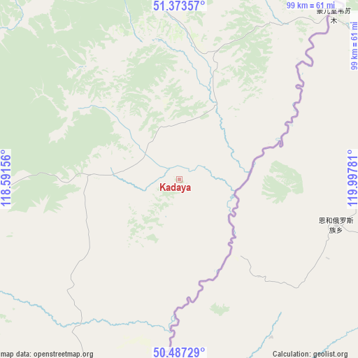
Kadaya GPS coordinates[2]
50° 55' 57.144" North, 119° 17' 40.848" East
| Map corner | latitude | longitude |
|---|---|---|
| Upper-left | 51.37357°, | 118.59156° |
| Center: | 50.93254°, | 119.29468° |
| Lower-right: | 50.48729°, | 119.99781° |
| Map W x H: | 98.5×98.5 km | = 61.2×61.2mi |
| max Lat: | 73.50819° ⇑75.2% North |
| Kadaya: | 50.93254° |
| min Lat: | ⇓24.8% South 41.28413° |
| min Long | Kadaya | max Long |
| -179.12198° | 119.29468° | 179.35046° |
| W 93%⇐ | ⇒7% E |
Elevation
Elevation of Kadaya is 625 m = 2051 ft, and this is 422.4 m = 1386 ft above average elevation for this country.
| Max E: |
2518 m = 8261 ft | 5.1% |
| Kadaya | 625 m 2051 ft | |
| Avg. | 202.6 m = 665 ft | |
Min E: |
-28 m = -92 ft | 94.9% |
See also: Russia elevation on elevation.city.
Geographical zone
Kadaya is located in North temperate zone (between Tropic of Cancer and the Arctic Circle). Distance of this North polar circle is 1738 km =1079.9 mi to North.| Distance of | km | miles | from Kadaya |
|---|---|---|---|
| North Pole | 4343.9 | 2699.2 | to North |
| Arctic Circle | 1738 | 1079.9 | to North |
| Tropic Cancer | 3057.2 | 1899.7 | to South |
| Equator | 5663.2 | 3518.9 | to South |


Nearby cities:
15 places around Kadaya: (largest is in red/bold)
• Abagaytuy
182.5 km =113.4 mi,  214°
214°
• Aleksandrovskiy Zavod
95.1 km =59.1 mi,  269°
269°
• Baley
198.7 km =123.5 mi,  291°
291°
• Gazimurskiy Zavod
95.6 km =59.4 mi,  316°
316°
• Kalanguy
194.7 km =121 mi, 272°
• Kalga
27.7 km =17.2 mi, 268°
• Klichka
106.3 km =66.1 mi,  239°
239°
• Kokuy
185.8 km =115.5 mi, 319°
• Krasnokamensk
128.5 km =79.8 mi,  223°
223°
• Nerchinskiy Zavod
47.4 km =29.5 mi,  28°
28°
• Priargunsk
64.1 km =39.8 mi,  192°
192°
• Shelopugino
144.6 km =89.9 mi,  303°
303°
• Sretensk
182.7 km =113.5 mi, 323°
• Vershino-Shakhtaminskiy
106.4 km =66.1 mi, 292°
• Zabaykal’sk
199.6 km =124 mi, 224°
Sources, notices
• [Note1] Compared only with cities in Russia existing in our database
• [Src1] Map data: © OpenStreetMap contributors (CC-BY-SA)
• [Src2] Other city data from geonames.org with taken over terms of usage.
• [Src3] Geographical zone / Annual Mean Temperature by Robert A. Rohde @ Wikipedia
