Dauriya geodata
Dauriya (Transbaikal Territory) is a populated place; located in Russia in Asia/Chita (GMT+9) time zone. With population of 4,058 people, there are 3076 cities with bigger population in this country. Compared to other cities in Russia, 78% of cities are located further ↑North; 92.5% of cities are located further ←West and 95.7% of cities have lower elevation than Dauriya. Note1


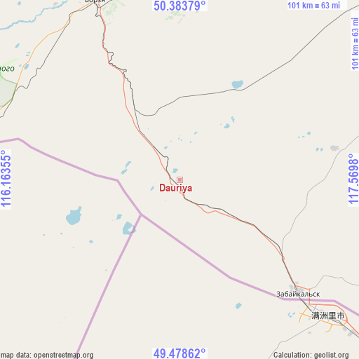
Dauriya GPS coordinates[2]
49° 55' 59.988" North, 116° 52' 0.012" East
| Map corner | latitude | longitude |
|---|---|---|
| Upper-left | 50.38379°, | 116.16355° |
| Center: | 49.93333°, | 116.86667° |
| Lower-right: | 49.47862°, | 117.5698° |
| Map W x H: | 100.6×100.6 km | = 62.5×62.5mi |
| max Lat: | 73.50819° ⇑78% North |
| Dauriya: | 49.93333° |
| min Lat: | ⇓22% South 41.28413° |
| min Long | Dauriya | max Long |
| -179.12198° | 116.86667° | 179.35046° |
| W 92.5%⇐ | ⇒7.5% E |
Elevation
Elevation of Dauriya is 677 m = 2221 ft, and this is 474.4 m = 1556 ft above average elevation for this country.
| Max E: |
2518 m = 8261 ft | 4.3% |
| Dauriya | 677 m 2221 ft | |
| Avg. | 202.6 m = 665 ft | |
Min E: |
-28 m = -92 ft | 95.7% |
See also: Russia elevation on elevation.city.
Geographical zone
Dauriya is located in North temperate zone (between Tropic of Cancer and the Arctic Circle). Distance of this North polar circle is 1849.1 km =1149 mi to North.| Distance of | km | miles | from Dauriya |
|---|---|---|---|
| North Pole | 4455 | 2768.2 | to North |
| Arctic Circle | 1849.1 | 1149 | to North |
| Tropic Cancer | 2946.1 | 1830.6 | to South |
| Equator | 5552.1 | 3449.9 | to South |


Nearby cities:
15 places around Dauriya: (largest is in red/bold)
• Abagaytuy
79.6 km =49.5 mi,  119°
119°
• Aleksandrovskiy Zavod
133.9 km =83.2 mi,  34°
34°
• Baley
184 km =114.3 mi,  354°
354°
• Borzya
55.9 km =34.7 mi,  333°
333°
• Budulan
156.6 km =97.3 mi,  296°
296°
• Guney
176.6 km =109.7 mi,  291°
291°
• Kalanguy
123 km =76.4 mi, 348°
• Kalga
181.4 km =112.7 mi,  52°
52°
• Klichka
98.5 km =61.2 mi, 54°
• Krasnokamensk
85.6 km =53.2 mi,  77°
77°
• Nizhniy Tsasuchey
139.3 km =86.6 mi, 297°
• Olovyannaya
145.8 km =90.6 mi,  320°
320°
• Priargunsk
166.4 km =103.4 mi,  73°
73°
• Vershino-Shakhtaminskiy
168.2 km =104.5 mi, 25°
• Zabaykal’sk
45.5 km =28.3 mi,  133°
133°
Sources, notices
• [Note1] Compared only with cities in Russia existing in our database
• [Src1] Map data: © OpenStreetMap contributors (CC-BY-SA)
• [Src2] Other city data from geonames.org with taken over terms of usage.
• [Src3] Geographical zone / Annual Mean Temperature by Robert A. Rohde @ Wikipedia
