Volgodonsk geodata
Volgodonsk (Rostov) is a populated place; located in Russia in Europe/Moscow (GMT+3) time zone. With population of 167,731 people, there are 113 cities with bigger population in this country. Compared to other cities in Russia, 81.3% of cities are located further ↑North; 59.1% of cities are located further →East and 84.6% of cities have higher elevation than Volgodonsk. Note1


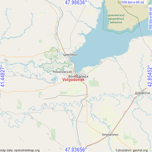
Volgodonsk GPS coordinates[2]
47° 30' 48.996" North, 42° 9' 5.004" East
| Map corner | latitude | longitude |
|---|---|---|
| Upper-left | 47.98636°, | 41.44827° |
| Center: | 47.51361°, | 42.15139° |
| Lower-right: | 47.03656°, | 42.85452° |
| Map W x H: | 105.6×105.6 km | = 65.6×65.6mi |
| max Lat: | 73.50819° ⇑81.3% North |
| Volgodonsk: | 47.51361° |
| min Lat: | ⇓18.7% South 41.28413° |
| min Long | Volgodonsk | max Long |
| -179.12198° | 42.15139° | 179.35046° |
| W 40.9%⇐ | ⇒59.1% E |
Elevation
Elevation of Volgodonsk is 49 m = 161 ft, and this is 153.6 m = 504 ft below average elevation for this country.
| Max E: |
2518 m = 8261 ft | 84.6% |
| Avg. | 202.6 m = 665 ft | |
| Volgodonsk | 49 m = 161 ft | |
Min E: |
-28 m = -92 ft | 15.4% |
See also: Volgodonsk elevation on elevation.city.
Geographical zone
Volgodonsk is located in North temperate zone (between Tropic of Cancer and the Arctic Circle). Distance of this North polar circle is 2118.2 km =1316.2 mi to North.| Distance of | km | miles | from Volgodonsk |
|---|---|---|---|
| North Pole | 4724 | 2935.4 | to North |
| Arctic Circle | 2118.2 | 1316.2 | to North |
| Tropic Cancer | 2677.1 | 1663.5 | to South |
| Equator | 5283 | 3282.7 | to South |


Nearby cities:
15 places around Volgodonsk: (largest is in red/bold)
• Bol’shaya Martynovka
45.2 km =28.1 mi,  233°
233°
• Dubovskoye
47.8 km =29.7 mi,  103°
103°
• Gundorovskiy
83.8 km =52.1 mi,  193°
193°
• Konstantinovsk
79.9 km =49.6 mi,  275°
275°
• Kotel’nikovo
75.3 km =46.8 mi,  80°
80°
• Krasnoarmeyskiy
56 km =34.8 mi,  175°
175°
• Krasnoyarskaya
3.3 km =2.1 mi,  128°
128°
• Krasnoyarskaya
17.2 km =10.7 mi,  332°
332°
• Nikolayevskaya
50 km =31.1 mi, 282°
• Orlovskiy
71.7 km =44.6 mi, 185°
• Proletarsk
95.7 km =59.5 mi,  199°
199°
• Romanovskaya
9.8 km =6.1 mi,  289°
289°
• Sovetskoye
88 km =54.7 mi, 180°
• Tsimlyansk
15.2 km =9.4 mi,  345°
345°
• Zimovniki
47.4 km =29.5 mi,  149°
149°
Sources, notices
• [Note1] Compared only with cities in Russia existing in our database
• [Src1] Map data: © OpenStreetMap contributors (CC-BY-SA)
• [Src2] Other city data from geonames.org with taken over terms of usage.
• [Src3] Geographical zone / Annual Mean Temperature by Robert A. Rohde @ Wikipedia
