Kalevala geodata
Kalevala (Karelia) is a populated place; located in Russia in Europe/Moscow (GMT+3) time zone. With population of 5,431 people, there are 2464 cities with bigger population in this country. Compared to other cities in Russia, 97.7% of cities are located further ↓South; 94.3% of cities are located further →East and 68.4% of cities have higher elevation than Kalevala. Note1


Kalevala GPS coordinates[2]
65° 11' 55.428" North, 31° 11' 23.964" East
| Map corner | latitude | longitude |
|---|---|---|
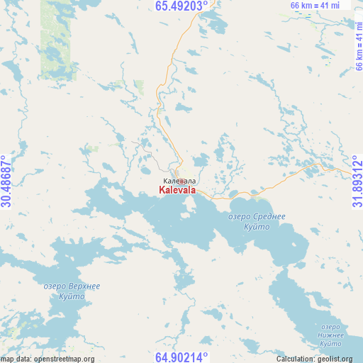
| Upper-left | 65.49203°, | 30.48687° |
| Center: | 65.19873°, | 31.18999° |
| Lower-right: | 64.90214°, | 31.89312° |
| Map W x H: | 65.6×65.6 km | = 40.8×40.8mi |
| max Lat: | 73.50819° ⇑2.3% North |
| Kalevala: | 65.19873° |
| min Lat: | ⇓97.7% South 41.28413° |
| min Long | Kalevala | max Long |
| -179.12198° | 31.18999° | 179.35046° |
| W 5.7%⇐ | ⇒94.3% E |
Elevation
Elevation of Kalevala is 106 m = 348 ft, and this is 96.6 m = 317 ft below average elevation for this country.
| Max E: |
2518 m = 8261 ft | 68.4% |
| Avg. | 202.6 m = 665 ft | |
| Kalevala | 106 m = 348 ft | |
Min E: |
-28 m = -92 ft | 31.6% |
See also: Russia elevation on elevation.city.
Geographical zone
Kalevala is located in North temperate zone (between Tropic of Cancer and the Arctic Circle). Distance of this North polar circle is 151.8 km =94.3 mi to North.| Distance of | km | miles | from Kalevala |
|---|---|---|---|
| North Pole | 2757.6 | 1713.5 | to North |
| Arctic Circle | 151.8 | 94.3 | to North |
| Tropic Cancer | 4643.5 | 2885.3 | to South |
| Equator | 7249.4 | 4504.6 | to South |


Nearby cities:
15 places around Kalevala: (largest is in red/bold)
• Ambarnyy
140.1 km =87.1 mi,  56°
56°
• Belomorsk
184.9 km =114.9 mi,  113°
113°
• Borovoy
82.2 km =51.1 mi,  142°
142°
• Chupa
146.4 km =91 mi,  35°
35°
• Engozero
142.6 km =88.6 mi, 62°
• Kem’
161.1 km =100.1 mi,  99°
99°
• Kostomuksha
75.6 km =47 mi,  202°
202°
• Ledmozero
112.3 km =69.8 mi,  159°
159°
• Loukhi
129.5 km =80.5 mi, 41°
• Muyezerskiy
143.2 km =89 mi, 164°
• Poyakonda
171.9 km =106.8 mi,  25°
25°
• Pyaozerskiy
63.5 km =39.5 mi,  355°
355°
• Rabocheostrovsk
169.1 km =105.1 mi, 98°
• Yushkozero
65.7 km =40.8 mi, 139°
• Zelenoborskiy
190.5 km =118.4 mi,  16°
16°
Sources, notices
• [Note1] Compared only with cities in Russia existing in our database
• [Src1] Map data: © OpenStreetMap contributors (CC-BY-SA)
• [Src2] Other city data from geonames.org with taken over terms of usage.
• [Src3] Geographical zone / Annual Mean Temperature by Robert A. Rohde @ Wikipedia
