Kem’ geodata
Kem’ (Karelia) is a populated place; located in Russia in Europe/Moscow (GMT+3) time zone. With population of 13,829 people, there are 1155 cities with bigger population in this country. Compared to other cities in Russia, 97.5% of cities are located further ↓South; 89.5% of cities are located further →East and 94% of cities have higher elevation than Kem’. Note1


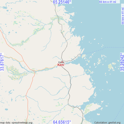
Kem’ GPS coordinates[2]
64° 57' 19.656" North, 34° 34' 45.444" East
| Map corner | latitude | longitude |
|---|---|---|
| Upper-left | 65.25146°, | 33.87617° |
| Center: | 64.95546°, | 34.57929° |
| Lower-right: | 64.65615°, | 35.28242° |
| Map W x H: | 66.2×66.2 km | = 41.1×41.1mi |
| max Lat: | 73.50819° ⇑2.5% North |
| Kem’: | 64.95546° |
| min Lat: | ⇓97.5% South 41.28413° |
| min Long | Kem’ | max Long |
| -179.12198° | 34.57929° | 179.35046° |
| W 10.5%⇐ | ⇒89.5% E |
Elevation
Elevation of Kem’ is 15 m = 49 ft, and this is 187.6 m = 615 ft below average elevation for this country.
| Max E: |
2518 m = 8261 ft | 94% |
| Avg. | 202.6 m = 665 ft | |
| Kem’ | 15 m = 49 ft | |
Min E: |
-28 m = -92 ft | 6% |
See also: Russia elevation on elevation.city.
Geographical zone
Kem’ is located in North temperate zone (between Tropic of Cancer and the Arctic Circle). Distance of this North polar circle is 178.8 km =111.1 mi to North.| Distance of | km | miles | from Kem’ |
|---|---|---|---|
| North Pole | 2784.7 | 1730.3 | to North |
| Arctic Circle | 178.8 | 111.1 | to North |
| Tropic Cancer | 4616.5 | 2868.6 | to South |
| Equator | 7222.4 | 4487.8 | to South |


Nearby cities:
15 places around Kem’: (largest is in red/bold)
• Ambarnyy
111.7 km =69.4 mi,  339°
339°
• Belomorsk
48.9 km =30.4 mi,  169°
169°
• Borovoy
116.8 km =72.6 mi,  250°
250°
• Chupa
162 km =100.7 mi,  334°
334°
• Engozero
97 km =60.3 mi, 342°
• Kalevala
161.1 km =100.1 mi,  279°
279°
• Ledmozero
144.5 km =89.8 mi,  237°
237°
• Loukhi
143.2 km =89 mi, 330°
• Muyezerskiy
166.6 km =103.5 mi,  228°
228°
• Nadvoitsy
121.7 km =75.6 mi,  185°
185°
• Pyaozerskiy
185.3 km =115.1 mi,  299°
299°
• Rabocheostrovsk
9.4 km =5.8 mi,  69°
69°
• Segezha
135.5 km =84.2 mi, 185°
• Solovetsky
53.7 km =33.4 mi,  81°
81°
• Yushkozero
119.2 km =74.1 mi,  259°
259°
Sources, notices
• [Note1] Compared only with cities in Russia existing in our database
• [Src1] Map data: © OpenStreetMap contributors (CC-BY-SA)
• [Src2] Other city data from geonames.org with taken over terms of usage.
• [Src3] Geographical zone / Annual Mean Temperature by Robert A. Rohde @ Wikipedia
