Rabocheostrovsk geodata
Rabocheostrovsk (Karelia) is a populated place; located in Russia in Europe/Moscow (GMT+3) time zone. With population of 2,900 people, there are 3824 cities with bigger population in this country. Compared to other cities in Russia, 97.5% of cities are located further ↓South; 89.3% of cities are located further →East and 98.8% of cities have higher elevation than Rabocheostrovsk. Note1


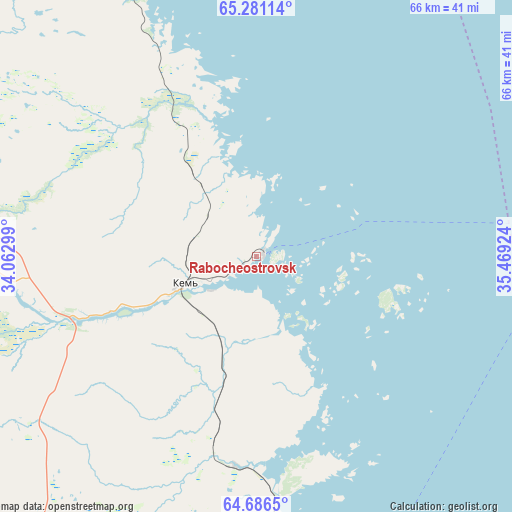
Rabocheostrovsk GPS coordinates[2]
64° 59' 7.692" North, 34° 45' 57.996" East
| Map corner | latitude | longitude |
|---|---|---|
| Upper-left | 65.28114°, | 34.06299° |
| Center: | 64.98547°, | 34.76611° |
| Lower-right: | 64.6865°, | 35.46924° |
| Map W x H: | 66.1×66.1 km | = 41.1×41.1mi |
| max Lat: | 73.50819° ⇑2.5% North |
| Rabocheostrovsk: | 64.98547° |
| min Lat: | ⇓97.5% South 41.28413° |
| min Long | Rabocheostrovsk | max Long |
| -179.12198° | 34.76611° | 179.35046° |
| W 10.7%⇐ | ⇒89.3% E |
Elevation
Elevation of Rabocheostrovsk is 1 m = 3 ft, and this is 201.6 m = 661 ft below average elevation for this country.
| Max E: |
2518 m = 8261 ft | 98.8% |
| Avg. | 202.6 m = 665 ft | |
| Rabocheostrovsk | 1 m = 3 ft | |
Min E: |
-28 m = -92 ft | 1.2% |
See also: Russia elevation on elevation.city.
Geographical zone
Rabocheostrovsk is located in North temperate zone (between Tropic of Cancer and the Arctic Circle). Distance of this North polar circle is 175.5 km =109.1 mi to North.| Distance of | km | miles | from Rabocheostrovsk |
|---|---|---|---|
| North Pole | 2781.4 | 1728.3 | to North |
| Arctic Circle | 175.5 | 109.1 | to North |
| Tropic Cancer | 4619.8 | 2870.6 | to South |
| Equator | 7225.7 | 4489.8 | to South |


Nearby cities:
15 places around Rabocheostrovsk: (largest is in red/bold)
• Ambarnyy
112 km =69.6 mi,  334°
334°
• Belomorsk
51.4 km =31.9 mi,  179°
179°
• Borovoy
126.2 km =78.4 mi,  250°
250°
• Chupa
163 km =101.3 mi, 331°
• Engozero
96.9 km =60.2 mi,  336°
336°
• Kalevala
169.1 km =105.1 mi,  278°
278°
• Kem’
9.4 km =5.8 mi, 249°
• Ledmozero
153.7 km =95.5 mi,  238°
238°
• Loukhi
144.8 km =90 mi, 326°
• Muyezerskiy
175.4 km =109 mi,  229°
229°
• Nadvoitsy
126.3 km =78.5 mi,  189°
189°
• Segezha
140 km =87 mi, 188°
• Solovetsky
44.6 km =27.7 mi,  84°
84°
• Umba
190.2 km =118.2 mi,  354°
354°
• Yushkozero
128.4 km =79.8 mi,  258°
258°
Sources, notices
• [Note1] Compared only with cities in Russia existing in our database
• [Src1] Map data: © OpenStreetMap contributors (CC-BY-SA)
• [Src2] Other city data from geonames.org with taken over terms of usage.
• [Src3] Geographical zone / Annual Mean Temperature by Robert A. Rohde @ Wikipedia
