Samagaltay geodata
Samagaltay (Republic of Tyva) is a populated place; located in Russia in Asia/Krasnoyarsk (GMT+7) time zone. With population of 3,477 people, there are 3415 cities with bigger population in this country. Compared to other cities in Russia, 76.3% of cities are located further ↑North; 87.3% of cities are located further ←West and 99.1% of cities have lower elevation than Samagaltay. Note1


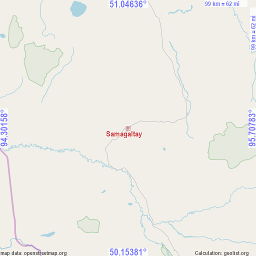
Samagaltay GPS coordinates[2]
50° 36' 7.92" North, 95° 0' 16.92" East
| Map corner | latitude | longitude |
|---|---|---|
| Upper-left | 51.04636°, | 94.30158° |
| Center: | 50.6022°, | 95.0047° |
| Lower-right: | 50.15381°, | 95.70783° |
| Map W x H: | 99.2×99.2 km | = 61.6×61.6mi |
| max Lat: | 73.50819° ⇑76.3% North |
| Samagaltay: | 50.6022° |
| min Lat: | ⇓23.7% South 41.28413° |
| min Long | Samagaltay | max Long |
| -179.12198° | 95.0047° | 179.35046° |
| W 87.3%⇐ | ⇒12.7% E |
Elevation
Elevation of Samagaltay is 1252 m = 4108 ft, and this is 1049.4 m = 3443 ft above average elevation for this country.
| Max E: |
2518 m = 8261 ft | 0.90000000000001% |
| Samagaltay | 1252 m 4108 ft | |
| Avg. | 202.6 m = 665 ft | |
Min E: |
-28 m = -92 ft | 99.1% |
See also: Russia elevation on elevation.city.
Geographical zone
Samagaltay is located in North temperate zone (between Tropic of Cancer and the Arctic Circle). Distance of this North polar circle is 1774.7 km =1102.7 mi to North.| Distance of | km | miles | from Samagaltay |
|---|---|---|---|
| North Pole | 4380.6 | 2722 | to North |
| Arctic Circle | 1774.7 | 1102.7 | to North |
| Tropic Cancer | 3020.5 | 1876.9 | to South |
| Equator | 5626.4 | 3496.1 | to South |


Nearby cities:
15 places around Samagaltay: (largest is in red/bold)
• Balgazyn
46.3 km =28.8 mi,  17°
17°
• Bay-Khaak
72.8 km =45.2 mi,  328°
328°
• Chadan
251.4 km =156.2 mi,  287°
287°
• Erzin
39.7 km =24.7 mi,  163°
163°
• Kaa-Khem
121.7 km =75.6 mi,  351°
351°
• Khandagayty
208.7 km =129.7 mi,  274°
274°
• Khovu-Aksy
108.2 km =67.2 mi,  303°
303°
• Kungurtug
177.7 km =110.4 mi,  90°
90°
• Kyzyl
129.1 km =80.2 mi,  342°
342°
• Saryg-Sep
106.2 km =66 mi, 21°
• Shagonar
178.1 km =110.7 mi,  305°
305°
• Sukpak
121.2 km =75.3 mi, 347°
• Sut-Khol’
274.7 km =170.7 mi, 289°
• Toora-Khem
221 km =137.3 mi, 20°
• Turan
187.4 km =116.4 mi, 336°
Sources, notices
• [Note1] Compared only with cities in Russia existing in our database
• [Src1] Map data: © OpenStreetMap contributors (CC-BY-SA)
• [Src2] Other city data from geonames.org with taken over terms of usage.
• [Src3] Geographical zone / Annual Mean Temperature by Robert A. Rohde @ Wikipedia
