Rwamagana geodata
Rwamagana (Eastern Province) is a seat of a first-order administrative division; located in Rwanda in Africa/Kigali (GMT+2) time zone. With population of 47,203 people, there are 8 cities with bigger population in this country. Compared to other cities in Rwanda, 69.2% of cities are located further ↓South; 92.3% of cities are located further ←West and 84.6% of cities have higher elevation than Rwamagana. Note1
Administrative division(s):
- Level 1: Eastern Province
- Level 2: Rwamagana District
- Level 3: Muhazi
- Level 4: Nyarusange


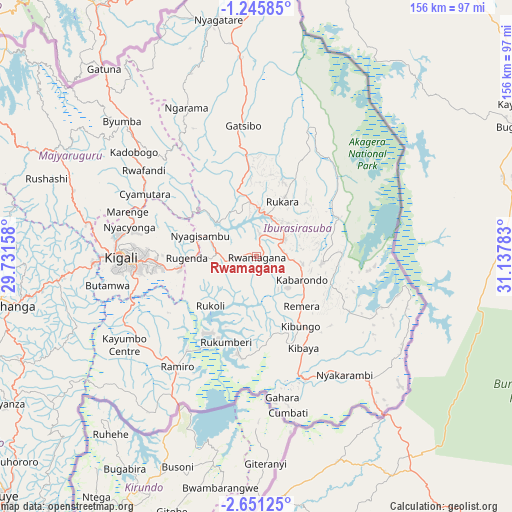
Rwamagana GPS coordinates[2]
1° 56' 55.32" South, 30° 26' 4.92" East
| Map corner | latitude | longitude |
|---|---|---|
| Upper-left | -1.24585°, | 29.73158° |
| Center: | -1.9487°, | 30.4347° |
| Lower-right: | -2.65125°, | 31.13783° |
| Map W x H: | 156.3×156.3 km | = 97.1×97.1mi |
| max Lat: | -1.49984° ⇑30.8% North |
| Rwamagana: | -1.9487° |
| min Lat: | ⇓69.2% South -2.59667° |
| min Long | Rwamagana | max Long |
| 28.9075° | 30.4347° | 30.5427° |
| W 92.3%⇐ | ⇒7.7% E |
Elevation
Elevation of Rwamagana is 1537 m = 5043 ft, and this is 199.9 m = 656 ft below average elevation for this country.
| Max E: |
2263 m = 7425 ft | 84.6% |
| Avg. | 1736.9 m = 5698 ft | |
| Rwamagana | 1537 m = 5043 ft | |
Min E: |
1461 m = 4793 ft | 15.4% |
See also: Rwamagana elevation on elevation.city.
Geographical zone
Rwamagana is located in South Torrid zone (between Equator and Tropic of Capricorn). Distance of Equator is 216.7 km =134.7 mi to North.| Distance of | km | miles | from Rwamagana |
|---|---|---|---|
| Equator | 216.7 | 134.7 | to North |
| Tropic Capricorn | 2389.2 | 1484.6 | to South |
| Antarctic Circle | 7184.5 | 4464.2 | to South |
| South Pole | 9790.4 | 6083.5 | to South |


Nearby cities:
13 places around Rwamagana: (largest is in red/bold)
• Butare
105.6 km =65.6 mi,  226°
226°
• Byumba
58.1 km =36.1 mi,  315°
315°
• Cyangugu
179.8 km =111.7 mi,  250°
250°
• Eglise Catholique, Centrale GIKO
69.9 km =43.4 mi,  271°
271°
• Gikongoro
111.5 km =69.3 mi,  239°
239°
• Gisenyi
133.8 km =83.1 mi,  281°
281°
• Gitarama
76.6 km =47.6 mi,  259°
259°
• Kibungo
26.4 km =16.4 mi,  152°
152°
• Kibuye
121.4 km =75.4 mi, 264°
• Kigali
41.8 km =26 mi, 269°
• Musanze
101.9 km =63.3 mi,  299°
299°
• Nyanza
88.2 km =54.8 mi, 239°
• Nzega
114 km =70.8 mi, 238°
Sources, notices
• [Note1] Compared only with cities in Rwanda existing in our database
• [Src1] Map data: © OpenStreetMap contributors (CC-BY-SA)
• [Src2] Other city data from geonames.org with taken over terms of usage.
• [Src3] Geographical zone / Annual Mean Temperature by Robert A. Rohde @ Wikipedia
