Byumba geodata
Byumba (Northern Province) is a seat of a first-order administrative division; located in Rwanda in Africa/Kigali (GMT+2) time zone. With population of 70,593 people, there are 5 cities with bigger population in this country. Compared to other cities in Rwanda, 92.3% of cities are located further ↓South; 84.6% of cities are located further ←West and 100% of cities have lower elevation than Byumba. Note1
Administrative division(s):
- Level 1: Northern Province
- Level 2: Gicumbi District
- Level 3: Byumba
- Level 4: Gisuna


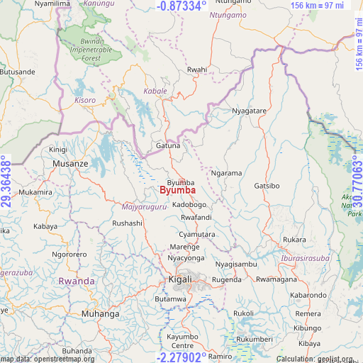
Byumba GPS coordinates[2]
1° 34' 34.68" South, 30° 4' 3" East
| Map corner | latitude | longitude |
|---|---|---|
| Upper-left | -0.87334°, | 29.36438° |
| Center: | -1.5763°, | 30.0675° |
| Lower-right: | -2.27902°, | 30.77063° |
| Map W x H: | 156.3×156.3 km | = 97.1×97.1mi |
| max Lat: | -1.49984° ⇑7.7% North |
| Byumba: | -1.5763° |
| min Lat: | ⇓92.3% South -2.59667° |
| min Long | Byumba | max Long |
| 28.9075° | 30.0675° | 30.5427° |
| W 84.6%⇐ | ⇒15.4% E |
Elevation
Elevation of Byumba is 2263 m = 7425 ft, and this is 526.1 m = 1726 ft above average elevation for this country.
| Max E: |
2263 m = 7425 ft | 0% |
| Byumba | 2263 m 7425 ft | |
| Avg. | 1736.9 m = 5698 ft | |
Min E: |
1461 m = 4793 ft | 100% |
See also: Byumba elevation on elevation.city.
Geographical zone
Byumba is located in South Torrid zone (between Equator and Tropic of Capricorn). Distance of Equator is 175.3 km =108.9 mi to North.| Distance of | km | miles | from Byumba |
|---|---|---|---|
| Equator | 175.3 | 108.9 | to North |
| Tropic Capricorn | 2430.7 | 1510.4 | to South |
| Antarctic Circle | 7225.9 | 4490 | to South |
| South Pole | 9831.8 | 6109.2 | to South |


Nearby cities:
13 places around Byumba: (largest is in red/bold)
• Butare
119.2 km =74.1 mi,  197°
197°
• Cyangugu
163.8 km =101.8 mi,  231°
231°
• Eglise Catholique, Centrale GIKO
49.5 km =30.8 mi,  215°
215°
• Gikongoro
112.9 km =70.2 mi,  209°
209°
• Gisenyi
91.2 km =56.7 mi,  261°
261°
• Gitarama
65.3 km =40.6 mi, 211°
• Kibungo
83.6 km =51.9 mi,  140°
140°
• Kibuye
96.4 km =59.9 mi,  236°
236°
• Kigali
41.6 km =25.8 mi,  181°
181°
• Musanze
48.8 km =30.3 mi,  280°
280°
• Nyanza
93.1 km =57.8 mi, 202°
• Nzega
115.3 km =71.6 mi, 209°
• Rwamagana
58.1 km =36.1 mi, 135°
Sources, notices
• [Note1] Compared only with cities in Rwanda existing in our database
• [Src1] Map data: © OpenStreetMap contributors (CC-BY-SA)
• [Src2] Other city data from geonames.org with taken over terms of usage.
• [Src3] Geographical zone / Annual Mean Temperature by Robert A. Rohde @ Wikipedia
