Kigali geodata
Kigali is a capital of a political entity; located in Rwanda in Africa/Kigali (GMT+2) time zone. With population of 745,261 people, there are 0 cities with bigger population in this country. Compared to other cities in Rwanda, 61.5% of cities are located further ↓South; 76.9% of cities are located further ←West and 76.9% of cities have higher elevation than Kigali. Note1
Administrative division(s):
- Level 1: Kigali
- Level 2: Nyarugenge District
- Level 3: Nyarugenge
- Level 4: Kiyovu


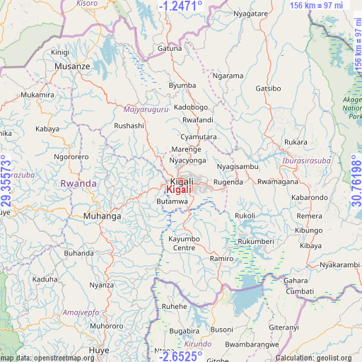
Kigali GPS coordinates[2]
1° 56' 59.82" South, 30° 3' 31.86" East
| Map corner | latitude | longitude |
|---|---|---|
| Upper-left | -1.2471°, | 29.35573° |
| Center: | -1.94995°, | 30.05885° |
| Lower-right: | -2.6525°, | 30.76198° |
| Map W x H: | 156.3×156.3 km | = 97.1×97.1mi |
| max Lat: | -1.49984° ⇑38.5% North |
| Kigali: | -1.94995° |
| min Lat: | ⇓61.5% South -2.59667° |
| min Long | Kigali | max Long |
| 28.9075° | 30.05885° | 30.5427° |
| W 76.9%⇐ | ⇒23.1% E |
Elevation
Elevation of Kigali is 1542 m = 5059 ft, and this is 194.9 m = 639 ft below average elevation for this country.
| Max E: |
2263 m = 7425 ft | 76.9% |
| Avg. | 1736.9 m = 5698 ft | |
| Kigali | 1542 m = 5059 ft | |
Min E: |
1461 m = 4793 ft | 23.1% |
See also: Kigali elevation on elevation.city.
Geographical zone
Kigali is located in South Torrid zone (between Equator and Tropic of Capricorn). Distance of Equator is 216.8 km =134.7 mi to North.| Distance of | km | miles | from Kigali |
|---|---|---|---|
| Equator | 216.8 | 134.7 | to North |
| Tropic Capricorn | 2389.1 | 1484.5 | to South |
| Antarctic Circle | 7184.4 | 4464.2 | to South |
| South Pole | 9790.2 | 6083.3 | to South |


Nearby cities:
13 places around Kigali: (largest is in red/bold)
• Butare
80.2 km =49.8 mi,  206°
206°
• Byumba
41.6 km =25.8 mi,  1°
1°
• Cyangugu
141.1 km =87.7 mi,  245°
245°
• Eglise Catholique, Centrale GIKO
28.1 km =17.5 mi,  273°
273°
• Gikongoro
78.5 km =48.8 mi,  223°
223°
• Gisenyi
93.3 km =58 mi,  287°
287°
• Gitarama
36.3 km =22.6 mi, 247°
• Kibungo
58.6 km =36.4 mi,  113°
113°
• Kibuye
80 km =49.7 mi,  261°
261°
• Musanze
68.7 km =42.7 mi,  316°
316°
• Nyanza
56.3 km =35 mi, 217°
• Nzega
81.1 km =50.4 mi, 223°
• Rwamagana
41.8 km =26 mi,  89°
89°
Sources, notices
• [Note1] Compared only with cities in Rwanda existing in our database
• [Src1] Map data: © OpenStreetMap contributors (CC-BY-SA)
• [Src2] Other city data from geonames.org with taken over terms of usage.
• [Src3] Geographical zone / Annual Mean Temperature by Robert A. Rohde @ Wikipedia
